
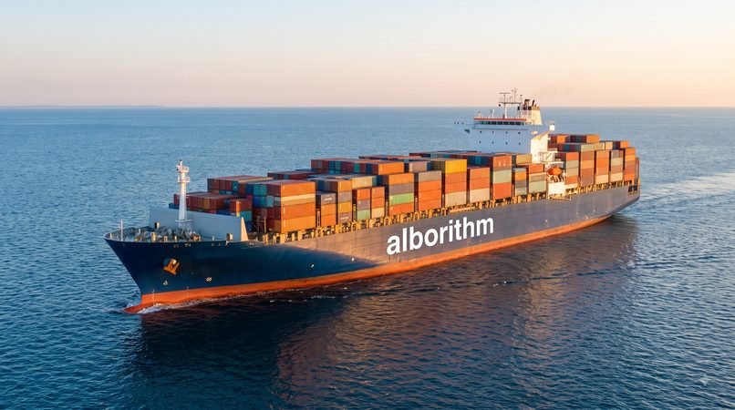
How humanity built the routes, networks, rules, institutions and technologies that connected the world—and why the entire system still depends on a few narrow doors !
At night in the Strait of Malacca, the horizon moves.
White mast lights slide past red and green navigation lamps. Tankers ride low with crude oil. Container ships advance like illuminated apartment blocks. Bulk carriers haul ore, coal and grain; car carriers present blank steel walls to the sea. On a bridge screen, each vessel is a name, course, speed and calculated point of closest approach. Beyond the screen, it is mass and momentum: ships from different flags, owned in one country, financed in another, crewed from several more, insured in London or elsewhere, carrying goods whose buyers may change before the cargo reaches port.
The sea appears limitless. The traffic is anything but free-form.
Ships file through surveyed lanes, separation schemes and narrow passages. They arrive against berth windows, canal bookings, customs declarations and charter-party clauses. Their containers fit cranes because distant engineers agreed on dimensions. Their documents trigger payment because banks recognize the rules. Their hulls enter foreign harbours because certificates issued under international conventions are accepted across borders. Naval patrols, coast guards, pilots, dredgers, tugboats, satellites, weather offices and software quietly make the voyage possible.
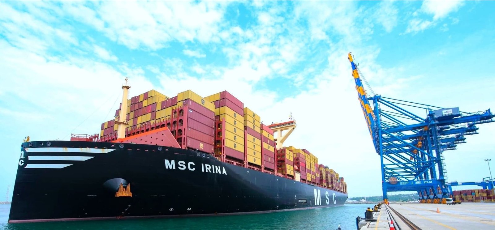
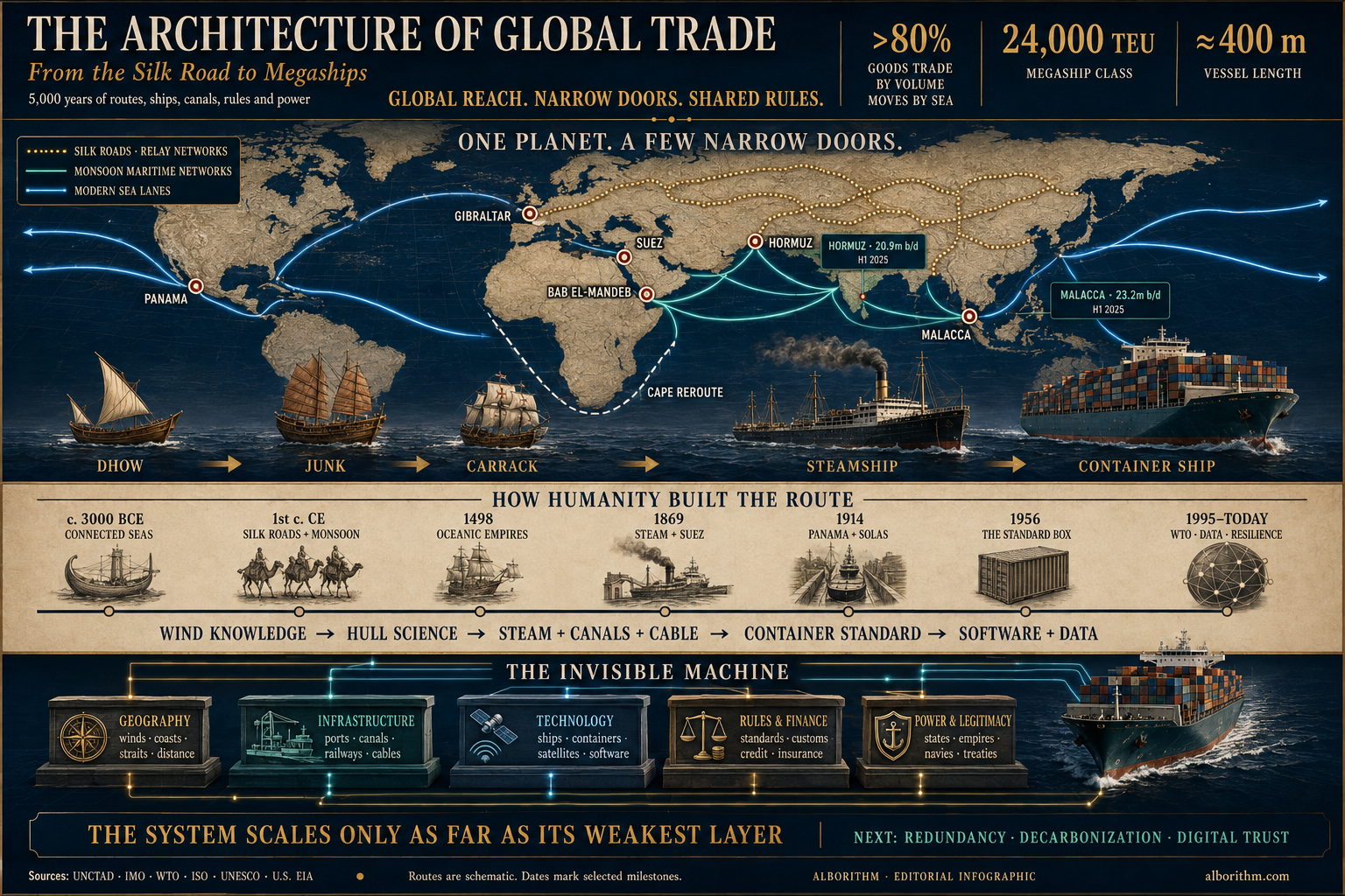
Then one of the giants comes close enough to erase the horizon. A vessel in the 24,000-TEU class can be roughly 400 metres long. Stand one upright and it would overtop the Empire State Building’s roof. Lay it beside a city block and the ship keeps going.
Yet its size is not the most extraordinary thing about it. The extraordinary thing is that the world has built a system capable of feeding it, guiding it, loading it, trusting it and receiving it.
Inside its boxes may be machine tools from East Asia, auto parts from Europe, coffee from Latin America, garments from South Asia, medical equipment, solar components, toys, frozen food and intermediate goods that will cross another border before they become finished products. The hull is only the visible part of a machine extending into farms, factories, rail terminals, warehouses, banks, insurers, customs offices, satellites, databases and naval strategy.
No architect drew that machine from a blank sheet. Humanity assembled it across five thousand years.
Egyptian expeditions tested Red Sea routes. Gulf sailors linked Mesopotamia and the Indus world. Phoenician and Greek ports thickened Mediterranean exchange. The Silk Roads contributed relay trade, protected way stations and commercial diasporas. Indian Ocean sailors turned monsoon winds into a timetable. Port cities learned to sell translation, credit, storage and access to rulers. Empires supplied roads, coinage and law—and demanded tax, obedience and sometimes monopoly. The age of sail tied the oceans together while fusing commerce with cannon and forced labour. Steam, coal stations, canals and telegraph cables made distance schedulable. After two world wars, governments built institutions to stabilize currencies, lower tariffs and standardize rules. Then the shipping container turned cargo into a universal module, and the megaship scaled that module almost beyond belief.
Today, more than 80 per cent of international trade in goods by volume travels by sea.[1] Global trade in goods and services surpassed $35 trillion in 2025.[2] Those numbers can make the network sound planetary and diffuse. In physical terms, it is neither. Much of it is channelled through a short list of straits, canals, port complexes, data systems and financial jurisdictions. A canal can be blocked by one ship. A strait can be threatened by missiles. A port can be paralysed by a cyberattack. A drought can reduce the number of vessels crossing an isthmus.
That is the central paradox of global trade: the system became vast by becoming concentrated.
This is the story of how the ocean became infrastructure—and how infrastructure became power.
The argument in one sentence
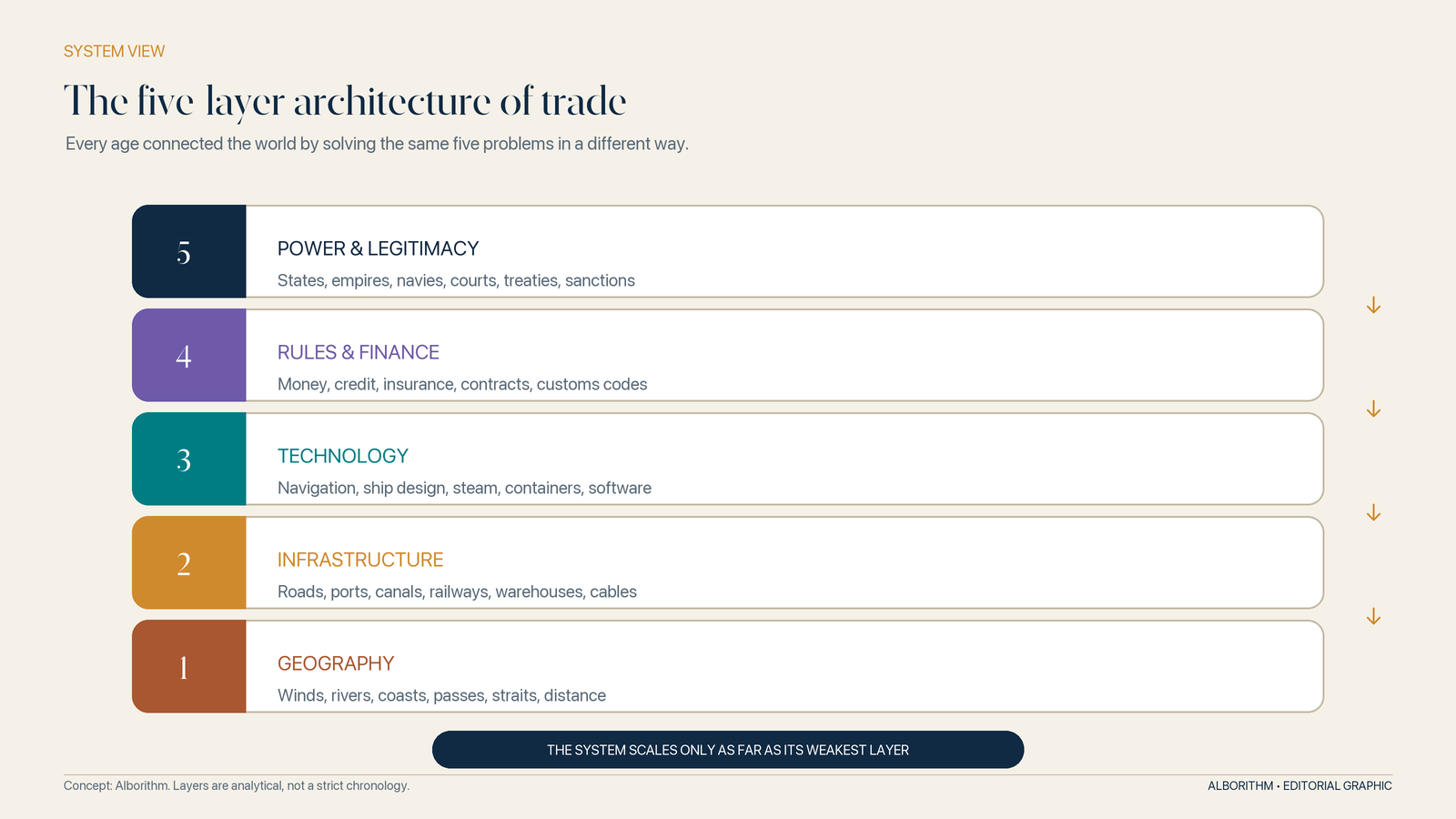
Global trade expands when societies reduce five kinds of friction at once: the friction of geography, infrastructure, technology, risk and political trust. It fractures when any one of those layers fails.
Global trade evolution at a glance
| Trading age | Route logic | Transformative technology | Trust and rules | Strategic power |
|---|---|---|---|---|
| Ancient and medieval | Coastal corridors, monsoon circuits and relay networks across caravan tracks and rivers | Sewn-plank ships, square sails, lateen rigs, junks, pack animals, ports and caravanserais | Merchant diasporas, customary law, coinage, weights and credit | Empires, temple economies, oasis cities and port rulers protected—and taxed—movement |
| Oceanic empires, c. 1500–1800 | Regular Atlantic, Indian Ocean and Pacific circuits | Ocean-going sail, cannon, fortified bases and navigational knowledge | Joint-stock capital, bills of lading and marine insurance | Chartered companies and navies turned routes into monopolies |
| Industrial age, c. 1800–1945 | Scheduled steamship and railway corridors | Steam, steel, screw propellers, canals and telegraph cables | Classification, commercial codes and faster financial information | Coal stations, colonial ports and control of Suez and Panama |
| Post-war order, 1945–2000 | Multilateral trade feeding intermodal networks | Containers, gantry cranes, highways, rail terminals and mainframes | IMF, GATT/WTO, IMO, WCO, ISO and standardized contracts | U.S.-backed sea lanes, alliances and development finance |
| Hyper-globalization, 2000–2020 | Hub-and-spoke shipping and fragmented value chains | Megaships, automated terminals, satellites and logistics software | Dense corporate networks, trade agreements and digital customs | Mega-ports, carrier alliances and infrastructure finance |
| Resilience era, 2020s onward | Diversified, security-screened and lower-carbon corridors | Sensors, AI planning, electronic documents and alternative-fuel ships | Carbon rules, supply-chain due diligence and data standards | Chokepoints, sanctions, industrial policy and climate exposure |
Before the Silk Road had a name, there was the sea
The first long-distance trade architecture did not begin with a line across Central Asia. It emerged where rivers reached sheltered water.
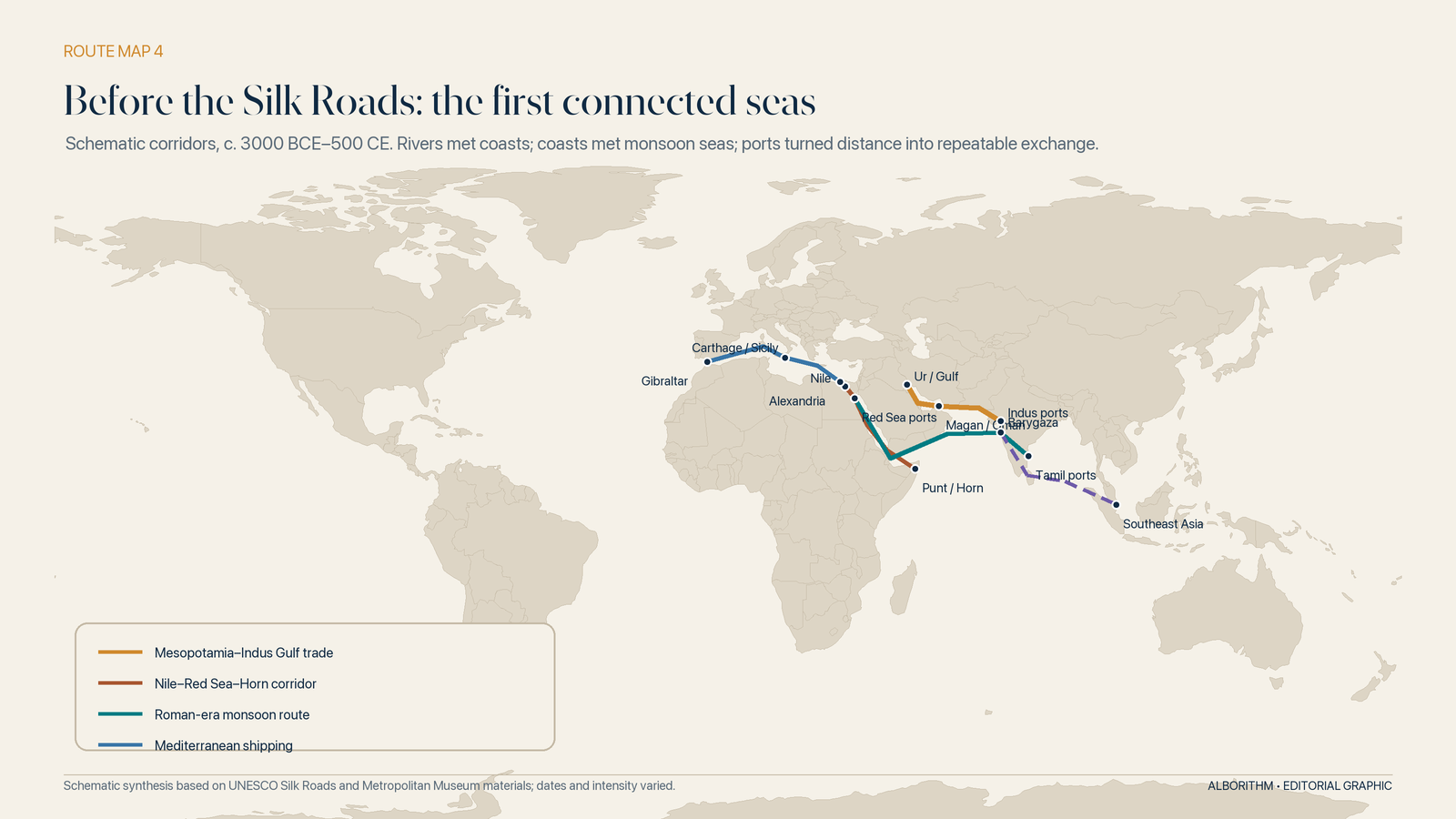
In the third millennium BCE, boats moved timber, metals, stone, grain, textiles and prestige goods through the Persian Gulf between Mesopotamia, Dilmun, Magan and the Indus world. The names changed; the commercial logic did not. A river system gathered production. A port concentrated cargo. A coastal or open-water vessel carried it farther than pack animals could do economically. Another port translated the cargo into a new political and commercial world.
Egypt faced a different geometry. The Nile was a north–south transport spine, but the Red Sea opened toward Arabia and the Horn of Africa. Around the fifteenth century BCE, Pharaoh Hatshepsut sent a celebrated expedition to Punt. Temple reliefs show ships, crews and the loading of incense trees and other cargo. The images are royal propaganda, not a modern bill of lading, yet they reveal something fundamental: rulers already understood maritime access as a project worthy of state organization and public memory.

Across the Mediterranean, Phoenician seafarers extended older Bronze Age exchanges through a network of harbours and colonies. Greek merchants established trading communities such as Naukratis in Egypt. Rome later converted the Mediterranean into an imperial supply system of extraordinary scale: Egyptian and North African grain, Spanish oil, Italian wine, metals, ceramics and enslaved people moved through specialized ports and warehouses. Ostia and Portus did not simply receive ships; they sorted, stored, accounted for and forwarded the food required by a vast capital.[37]
This is the first recurring lesson of trade history. The ship never works alone. Its carrying power matters only when matched by ports, pilots, warehouses, weights, taxes, credit and political guarantees on both shores.
The world before “global”: trade by relay
There was never one Silk Road.
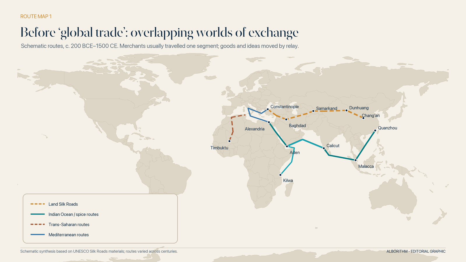
The phrase was coined only in the nineteenth century, long after the caravan tracks, river valleys and maritime passages it describes had been in use. What existed was a changing web across Eurasia: multiple routes that opened, shifted or disappeared as rulers changed, wars moved and water sources failed. UNESCO describes them in the plural—land and sea corridors linking communities across East Asia, Central Asia, South Asia, West Asia, Africa and Europe.[3]
Nor did most merchants journey from China to Rome. The romantic picture of a lone caravan crossing a continent mistakes the movement of goods for the movement of people. A bolt of silk, a bag of pepper or a piece of glass could travel farther than any one trader who handled it. Goods passed through chains of intermediaries: Chinese, Sogdian, Persian, Arab, Armenian, Indian, Jewish, Greek and many others. Each knew a segment, a language, a set of taxes, a credit network and a way through local danger.
The route, in other words, was not a road. It was a sequence of trusted handoffs.
The caravanserai: an ancient logistics platform
On the strongest land corridors, inns known as caravanserais appeared roughly a day’s journey apart—often 30 to 40 kilometres in well-served regions.[3] Their walls offered security. Their courtyards held pack animals. Their storerooms sheltered cargo. Their markets brought buyers, sellers, translators, money changers and news into one place.
Calling a caravanserai an “ancient truck stop” captures the rest and resupply, but misses its institutional role. It was also a warehouse, exchange, hotel, information hub and risk-control mechanism. It made the next handoff more predictable. Forts, beacon towers, posthouses, wells and irrigated settlements formed the supporting infrastructure. UNESCO’s Chang’an–Tianshan corridor alone covers a 5,000-kilometre section of a network whose specific routes exceeded 35,000 kilometres.[4]
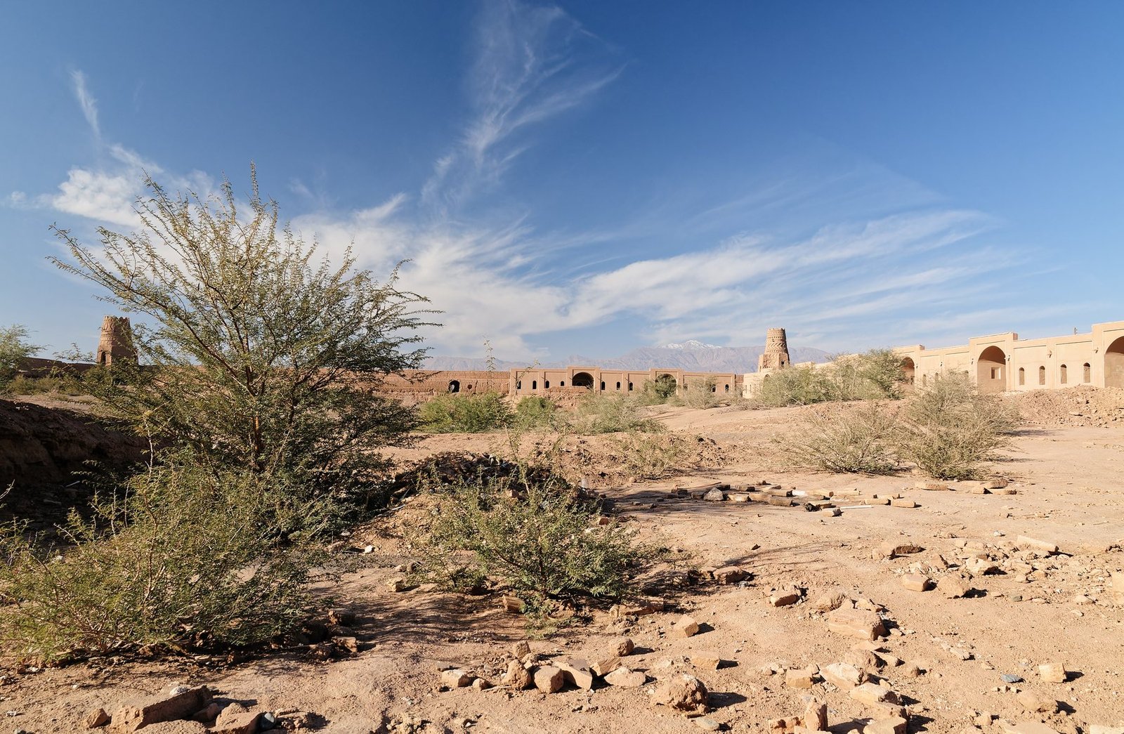
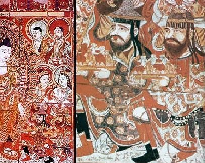
The contents of the caravans were far broader than silk. Textiles, dyes, horses, metalwork, jade, glass, paper, precious stones, medicines, fruit, grain, ceramics and religious objects moved along the network. So did techniques and beliefs. Buddhism travelled into China. Papermaking moved west. Artistic motifs crossed languages. Disease moved too. Connectivity never carried only benefits.
That double movement—goods one way, consequences in every direction—will repeat throughout the history of global trade.
The Sea Road hidden inside the Silk Roads
Land routes dominate the popular imagination because caravans photograph well. For moving bulk, however, water has always had an advantage. A hull can carry what would require many animals, drivers and meals on land.
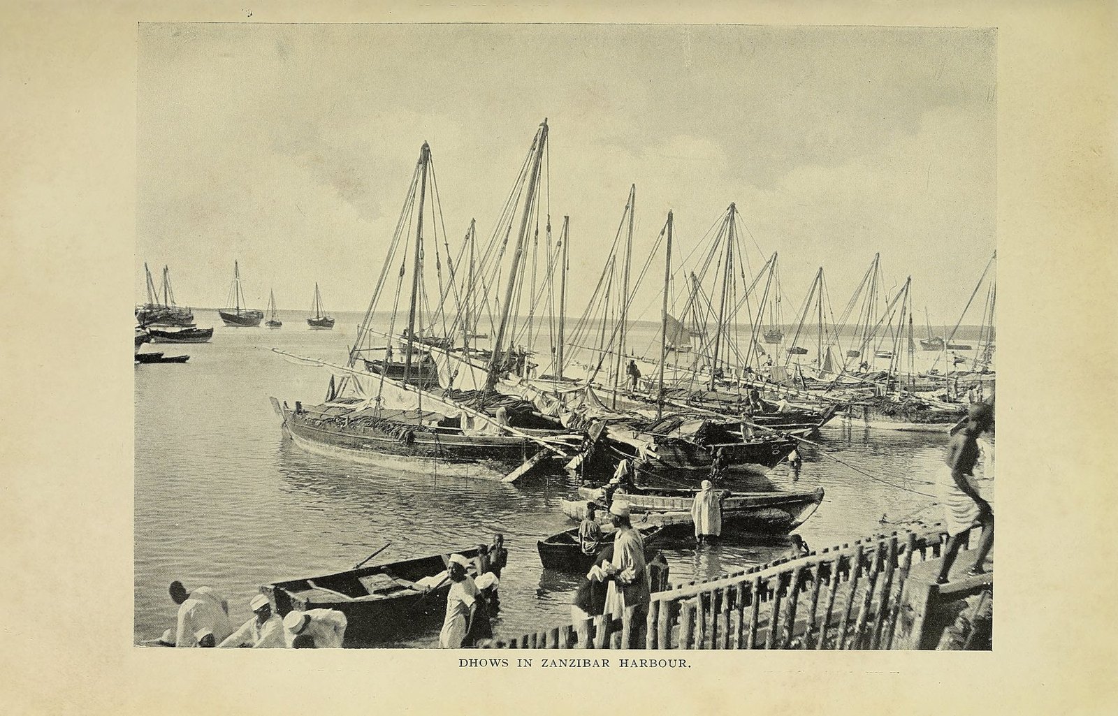
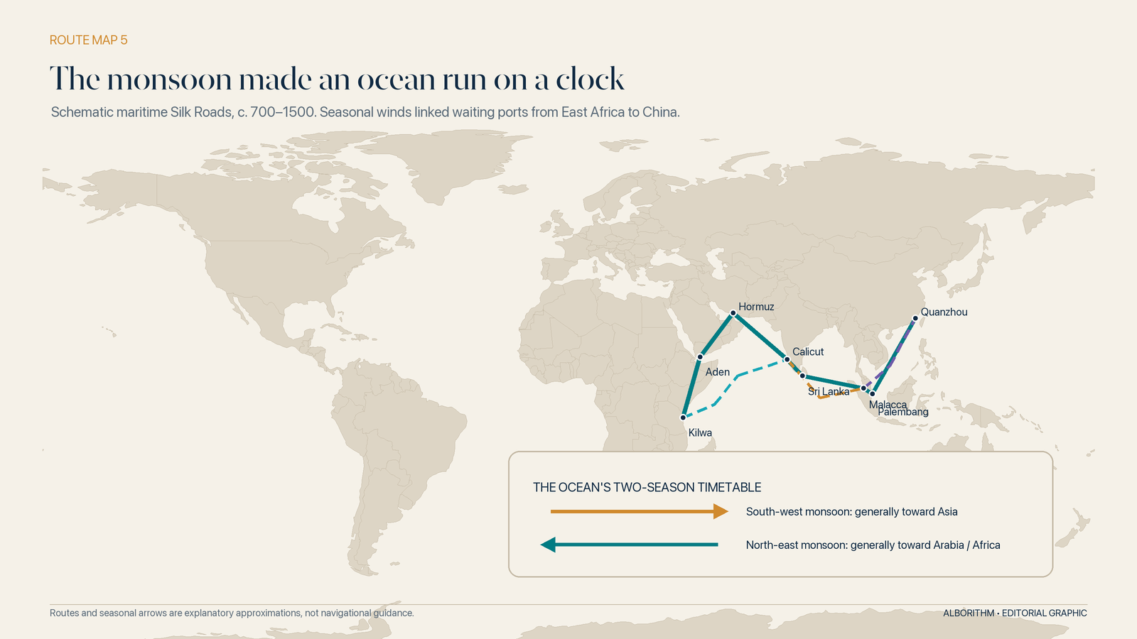
Long before European fleets entered the Indian Ocean, sailors from East Africa, Arabia, Persia, India, Southeast Asia and China had built a dense commercial world around it. They did not defeat geography; they learned its rhythm. The south-west monsoon carried vessels across part of the ocean in one season, and the north-east monsoon helped carry them back in another. Ports became waiting rooms for the wind.
The mid-first-century Periplus of the Erythraean Sea reads like an early mariner’s commercial directory: distances, winds, harbours, imports and exports from the Red Sea to East Africa and India.[5] Centuries later, around 830 CE, a ship sailing west from China sank near Belitung Island with more than 60,000 items aboard, most of them Chinese ceramics intended for distant markets.[6] That wreck is evidence not of occasional contact but of volume, specialization and organized demand.
East African cities such as Kilwa and Mombasa exported gold, ivory, timber and other goods; imported ceramics and beads survive as archaeological proof of their reach. Aden, Hormuz, Calicut, Malacca, Quanzhou, Alexandria and Zanzibar were not peripheral stops on a European story. They were central nodes in commercial systems with their own capital, law, languages and merchant communities.
The monsoon did more than push sails. It organized business. A merchant who reached Calicut after the favourable wind had turned could wait months for the return season. That delay created demand for warehouses, agents, lodging, interpreters, money changers and credit. Seasonal nature made the ocean less like an empty space and more like a vast railway whose timetable was written in pressure and rain.
Shipbuilders responded to different seas with different answers. Indian Ocean craft used sewn or lashed construction for centuries and carried lateen or related fore-and-aft rigs suited to regional winds. Chinese oceangoing junks combined capacious hulls, stern-mounted rudders, battened sails and transverse bulkheads. Mediterranean and northern European builders developed their own traditions. There was no single ladder from “primitive” to “modern”; there were overlapping schools of maritime engineering, each optimized for cargo, coast, material, weather and labour.
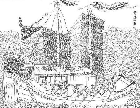
Quanzhou demonstrates what happened when ship technology met institutional depth. Under the Song and Yuan dynasties it became one of the world’s great maritime emporia, linked to ports across Southeast Asia, South Asia, the Gulf and East Africa. Its religious sites record resident Muslim, Hindu and other communities; its docks and shipwrecks record ocean-going capacity. UNESCO describes the city not as one isolated harbour but as a system of production sites, transport links, administrative offices, temples and commercial facilities.[38]
The Brokers’ Ocean: ports that translated the world
A harbour becomes a global port when strangers can do business there without first becoming local.
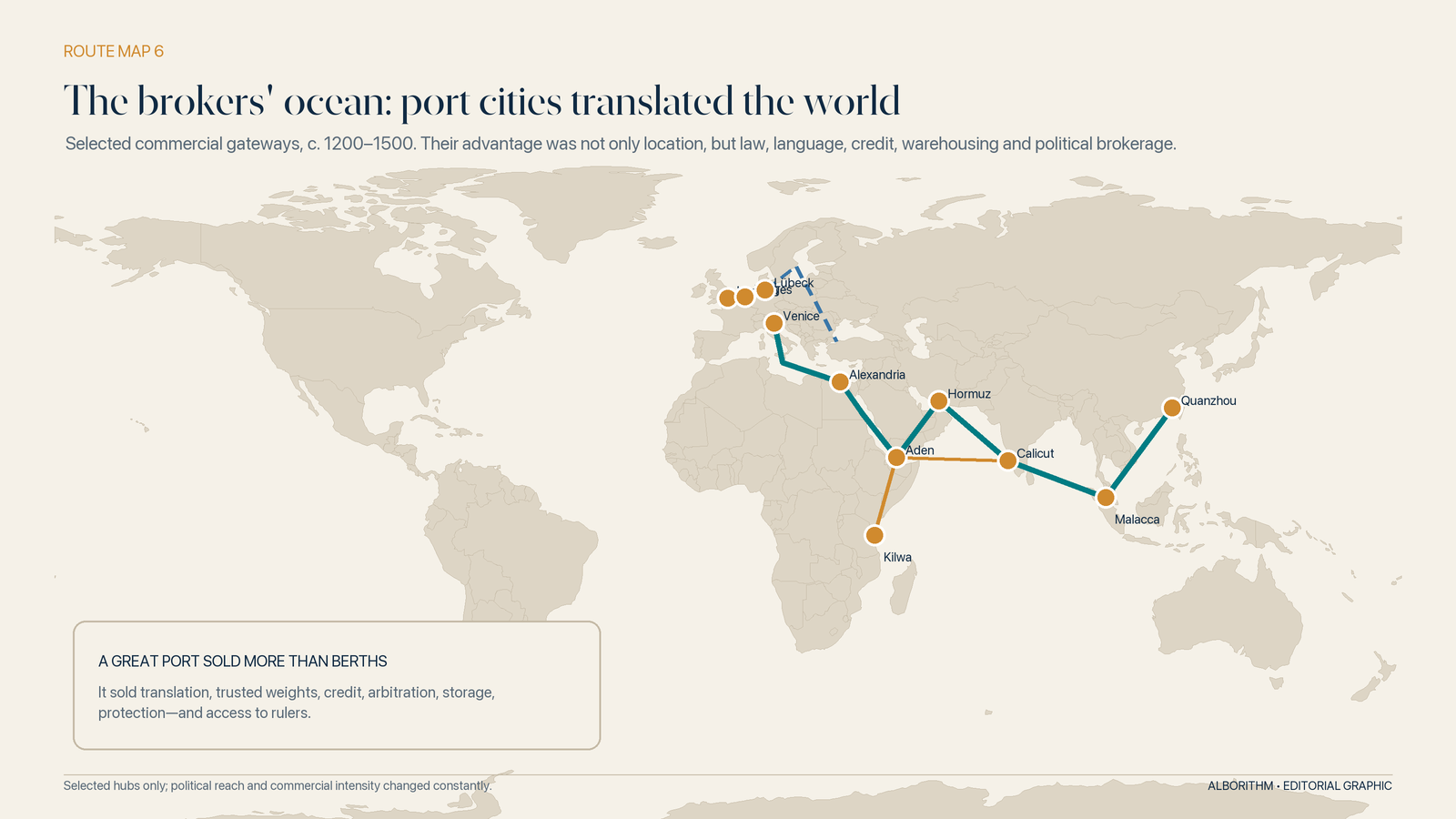
That requires translation in the broadest sense. Cargo needs recognized weights and measures. Foreign money needs a rate of exchange. A damaged shipment needs an arbitrator. A captain needs pilots who know the shoals. Merchants need warehouses, guards and a way to enforce promises after the ship has sailed. Rulers want customs revenue without driving trade to the rival port down the coast.
The most successful entrepôts turned these frictions into a product.
Aden, Hormuz and Calicut: the art of sitting between worlds
Aden guarded the approach between the Red Sea and Indian Ocean. Hormuz profited from the Gulf’s narrow entrance. Calicut connected the pepper-producing Malabar Coast to merchants arriving from the Arabian Sea and beyond. Their rulers did not need to manufacture every valuable commodity. They needed to make exchange sufficiently safe, liquid and convenient that cargo would concentrate in their markets.
The same logic appears in Venice. Its merchants dealt repeatedly with Mamluk, Ottoman and Safavid counterparts, negotiated privileges, maintained colonies and used interpreters known as dragomans. State-organized convoys joined security to schedule. Farther north, the Hanseatic League connected more than two hundred towns at different times through shared privileges, legal coordination and trading outposts in places such as Novgorod, Bergen, Bruges and London.[39] Neither network abolished political rivalry. Both reduced the cost of operating across it.
Malacca: where the winds, merchants and empires met
Few places reveal the architecture more clearly than Melaka—Malacca—on the strait between the Malay Peninsula and Sumatra.
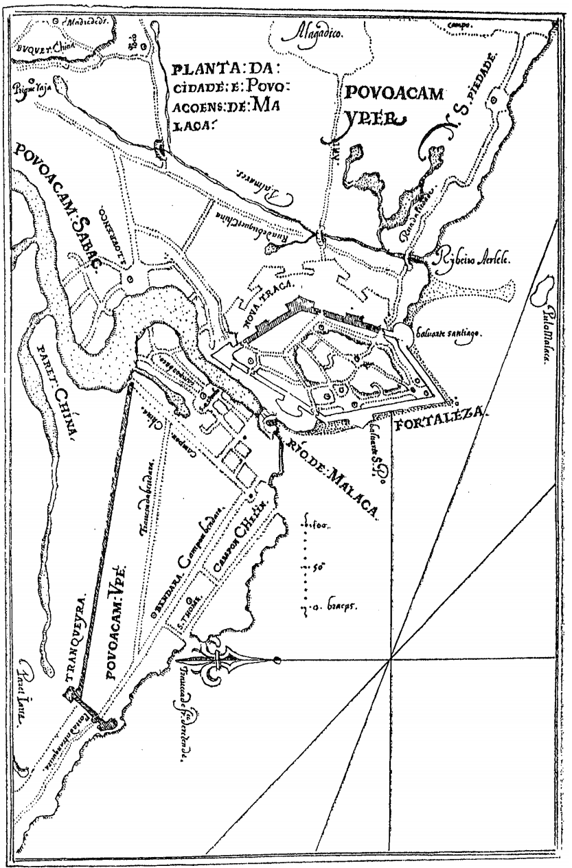
The strait is a natural funnel between the Indian Ocean and the South China Sea. But geography alone did not make the sultanate great. Malacca’s advantage was organized brokerage: harbour officials, merchant communities, storage, predictable levies, political protection and access to a marketplace where one monsoon system handed cargo to another. Gujarati, Tamil, Arab, Persian, Javanese and Chinese merchants could arrive with different languages, religions and commercial customs yet participate in the same port economy. UNESCO’s historical materials describe Melaka as one of the crucial entrepôts of the maritime highway through Southeast Asia.[40]
When the Portuguese seized Malacca in 1511, they were not merely taking a city. They were trying to capture a switchboard.
The first operating system: protection, tax and trust
A route becomes a network only when people can use it repeatedly.
That requires more than a trail and a camel. Merchants need to know where taxes will be collected, which coin or weight will be accepted, whether a contract can be enforced, who will answer for stolen cargo and whether a ruler’s guarantee will survive the ruler. The earliest architecture of trade was therefore political.
The Persian Royal Road, Roman roads and ports, Han frontier systems, Islamic commercial law, South Asian merchant guilds and Chinese canal networks were different answers to the same question: how can authority make distance legible?
Empires often lowered internal barriers while raising them at their edges. They patrolled roads, maintained infrastructure, punished banditry and standardized tribute. In return they taxed movement, channelled it through preferred gates and sometimes restricted strategic goods. The bargain was never simply “peace for commerce.” It was access in exchange for revenue and obedience.
The Mongol moment: a continent compressed, not pacified
The thirteenth-century Mongol conquests were catastrophic for many populations. Yet the successor khanates also connected an unusually large share of Eurasia under related regimes. Protected envoys carried tablets of authority. Postal-relay stations accelerated official travel. Merchant partnerships linked court capital to long-distance commerce. Silver could be used as a common unit of account across an enormous region, while Yuan paper money altered monetary flows in the east.[7]
The familiar label Pax Mongolica should not be mistaken for universal peace. Routes remained dangerous; wars among Mongol states continued; the Black Death itself followed channels of human mobility. What changed was the scale at which diplomatic credentials, commercial privileges and political intelligence could travel.
Marco Polo became famous because he wrote for a European audience. He was not evidence of Europe discovering an empty road. He entered a Eurasian system built and used by others.
This distinction matters. Global trade has rarely advanced because one civilization “opened” the world. It has advanced when many regional systems became interoperable—sometimes by exchange, sometimes under empire, usually through a mixture of both.
Zheng He’s floating court
In 1405, a Ming fleet commanded by the Muslim court official Zheng He sailed from China toward Southeast Asia and the Indian Ocean. It was the first of seven expeditions completed by 1433. The voyages reached India, the Gulf and East Africa, carried Chinese goods outward, brought envoys and rarities back, and projected the Yongle emperor’s authority across maritime networks China had not created but could now enter on spectacular terms.[43]
Picture the arrival from the quay. Not one ship nosing into harbour, but a moving court: soldiers, interpreters, navigators, scribes, diplomats, merchants, doctors, ritual gifts and imperial orders. The fleet’s power lay in coordination. Shipyards, taxation, grain supply, river transport, coastal bases and political command had to converge before the sails could rise.
The expeditions ended; Indian Ocean commerce did not. Private and diasporic trade continued through the ports and seasonal circuits that had sustained it before the armada. Zheng He’s voyages therefore expose the difference between a route and a regime. An emperor can amplify a network, intimidate its rulers and redirect prestige. The network survives only if thousands of ordinary exchanges still make sense after the fleet goes home.
The ship is not a vehicle. It is a business model
Every major change in merchant shipping altered three calculations at once: how much could be carried, how predictably it could arrive and who could control the voyage.
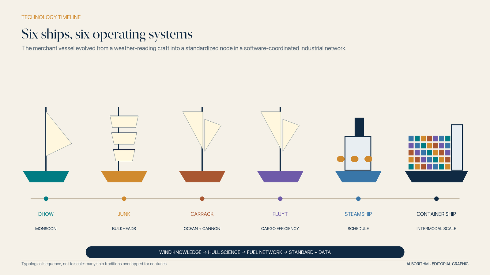
A dhow using monsoon knowledge was a seasonal machine. A junk divided by bulkheads was a cargo platform engineered for capacity and survivability. A cog offered northern European merchants a broad single-masted carrier that could also be defended. A carrack combined ocean range, cargo space and gun power. A fluyt stripped away much of the military burden to maximize earning space and reduce crew requirements. A clipper sacrificed volume for speed when tea prices rewarded the first arrivals. A steamship sold schedule. A container ship sells standardized transfer between modes.
Sail: converting weather knowledge into capital
Sailing ships could cross oceans without carrying fuel, but they did not travel for free. They converted rigging, sailcloth, timber, crew skill and knowledge of winds into propulsion. Their commercial range depended on food, water, hull maintenance, cargo preservation and the ability to survive long periods without external help.
The critical technology was often not a spectacular invention but a bundle: stronger hull joints, better steering, more flexible sail plans, improved charts, portolan knowledge, magnetic compasses, celestial observation and accumulated pilotage. When bundled together, those improvements allowed ships to leave coastal routes, carry more stores and return with a better chance of arriving at the intended market.
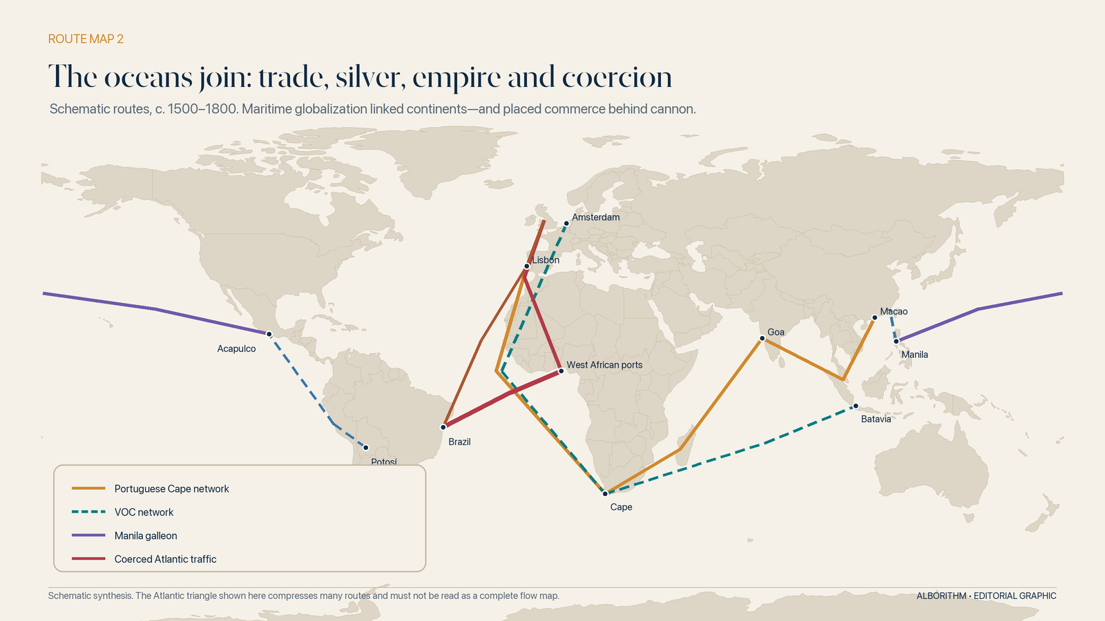
1498 did not create the ocean. It militarized the route
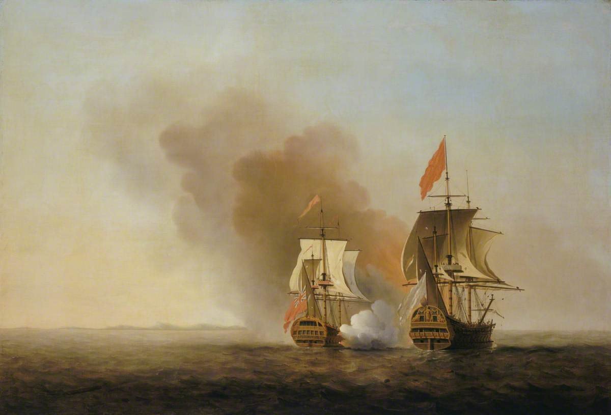
When Vasco da Gama reached India by sailing around the Cape of Good Hope in 1498, he entered a thriving ocean economy. The Portuguese advantage was not that they had invented Indian Ocean trade. It was that they arrived with ocean-going cannon, a crown-backed strategy and a determination to control passages, ports and permits.
Their cartaz system made the ambition explicit. Ships could be required to purchase a pass specifying vessel, route and cargo; those sailing without one risked seizure. Forts at strategic nodes and armed patrols gave the paper force. It was an early attempt to combine maritime surveillance, licensing, taxation and coercion across an ocean—a rough imperial ancestor of the document checks that still structure shipping, stripped of today’s multilateral legitimacy.[42]
The ship itself was changing purpose. Large carracks combined square sails for open-water power with a triangular after-sail for manoeuvring, while gunports allowed cannon to fire through the hull. The later Dutch fluyt pushed in another direction: an elongated, capacious freighter built around the economics of cargo. One design fused trade with force; the other pursued carrying efficiency. Both foreshadowed the modern argument over what a merchant ship is meant to optimize.[36]
European maritime expansion joined navigation to organized violence. Fortified bases, armed convoys and monopoly charters made trade an instrument of state competition. The objective was not merely to participate in markets but to redirect them, tax them and deny rivals access.
The oceanic age produced a genuine change in scale. Atlantic, Indian Ocean and Pacific systems became tied together through regular routes. But it did not produce a neutral world market. It produced imperial networks whose rules were written by those able to put guns beside warehouses.
Silver closes the first global circuit
The missing link was the Pacific.
From 1565 to 1815, the Manila galleons connected the Philippines and Acapulco. Asian porcelain, silk, ivory and spices travelled east across the Pacific; American silver moved west. Goods landed in Mexico could cross overland and continue to Atlantic ports and Europe. Chinese demand for silver pulled the metal onward into Asian markets.[8]
This was one of the first durable systems in which a shock, price or policy on one continent could propagate through all the others. Mines in Spanish America, Chinese tax and monetary demand, Japanese and Chinese production, Filipino and Chinese merchants, Mexican carriers, Spanish imperial law and Pacific navigation became parts of a single circuit.
That circuit carried living organisms as well as silver. Crops, animals, pathogens and people crossed ecological boundaries in the Columbian Exchange. Food systems changed. Populations collapsed under disease and conquest. Species became global stowaways. Trade’s geography was now planetary; so were its externalities.
The corporation becomes an arm of empire
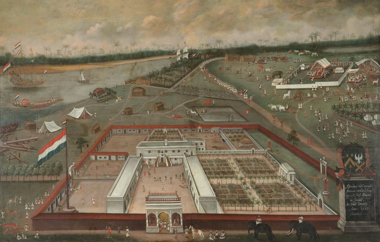
In 1602, the Dutch East India Company—the VOC—received a monopoly on Dutch trade east of the Cape of Good Hope. It could wage war, sign treaties and administer territory. The company pooled capital, spread risk and created continuity beyond a single voyage. It also used force to build and defend a network of hundreds of bases.[9]
This was a profound institutional innovation: the state delegated sovereign powers to a commercial corporation. The company’s ships carried spices, textiles, timber, tea, coffee and porcelain. Its offices carried accounts, intelligence, orders and claims. Its forts made the contract credible because its cannon made refusal costly.
The architecture’s darkest load-bearing wall
Any history that presents early globalization as a widening circle of voluntary exchange is false.
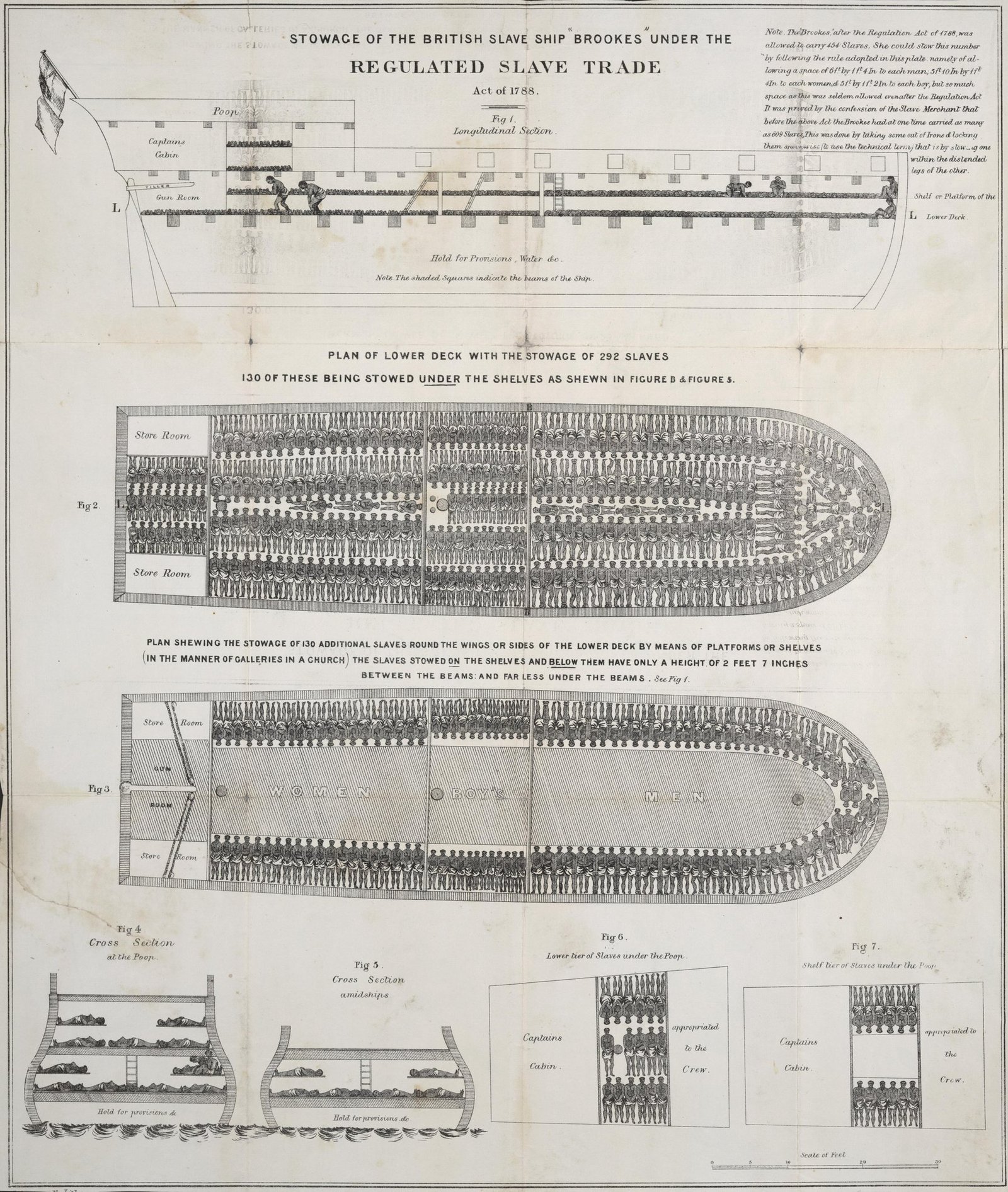
The Atlantic plantation economy was built on land seizure and the forced movement of human beings. The SlaveVoyages project estimates that about 12.5 million captive Africans were embarked for the Americas between 1501 and 1866; roughly 10.7 million survived to disembark.[10] Ships, credit, insurance, port infrastructure, commodity markets and law were engineered around that traffic.
Sugar, tobacco, coffee, cotton, indigo and other commodities moved through networks whose low prices and enormous profits rested on coerced labour. Financial institutions did not stand outside the violence. Marine insurers helped distribute the risks. Lloyd’s, which grew from a London coffee house specializing in shipping intelligence, has documented its own market’s entanglement with the slave economy.[11]
The system was “efficient” for those measuring cargo and returns because it classified people as cargo. That is not an incidental moral footnote. It is evidence that infrastructure and institutions can optimize an evil objective as readily as a humane one.
Steam, canals and cable: when distance became scheduled
Sail made global routes possible. Steam made them regular.
A sailing vessel negotiated with wind. A steamship bought independence with coal. Early steam power did not erase the weather, and coaling created a new network of dependencies, but it made arrival times less seasonal and routes more programmable. Iron and then steel hulls increased scale. Screw propellers improved propulsion. Railways drove corridors deep into continents and synchronized ports with inland production.
The transformation was not simply faster transport. It was the birth of the timetable.
Predictable arrivals reduced inventory uncertainty. Manufacturers could coordinate inputs. Banks could price voyages with better information. Commodity exchanges could trade contracts against expected deliveries. Port cities expanded where rail, river and sea met. Geography did not disappear; fixed infrastructure made some geographies vastly more valuable.
The clipper’s magnificent dead end
Just before steam won the schedule, sail reached an exquisite extreme.
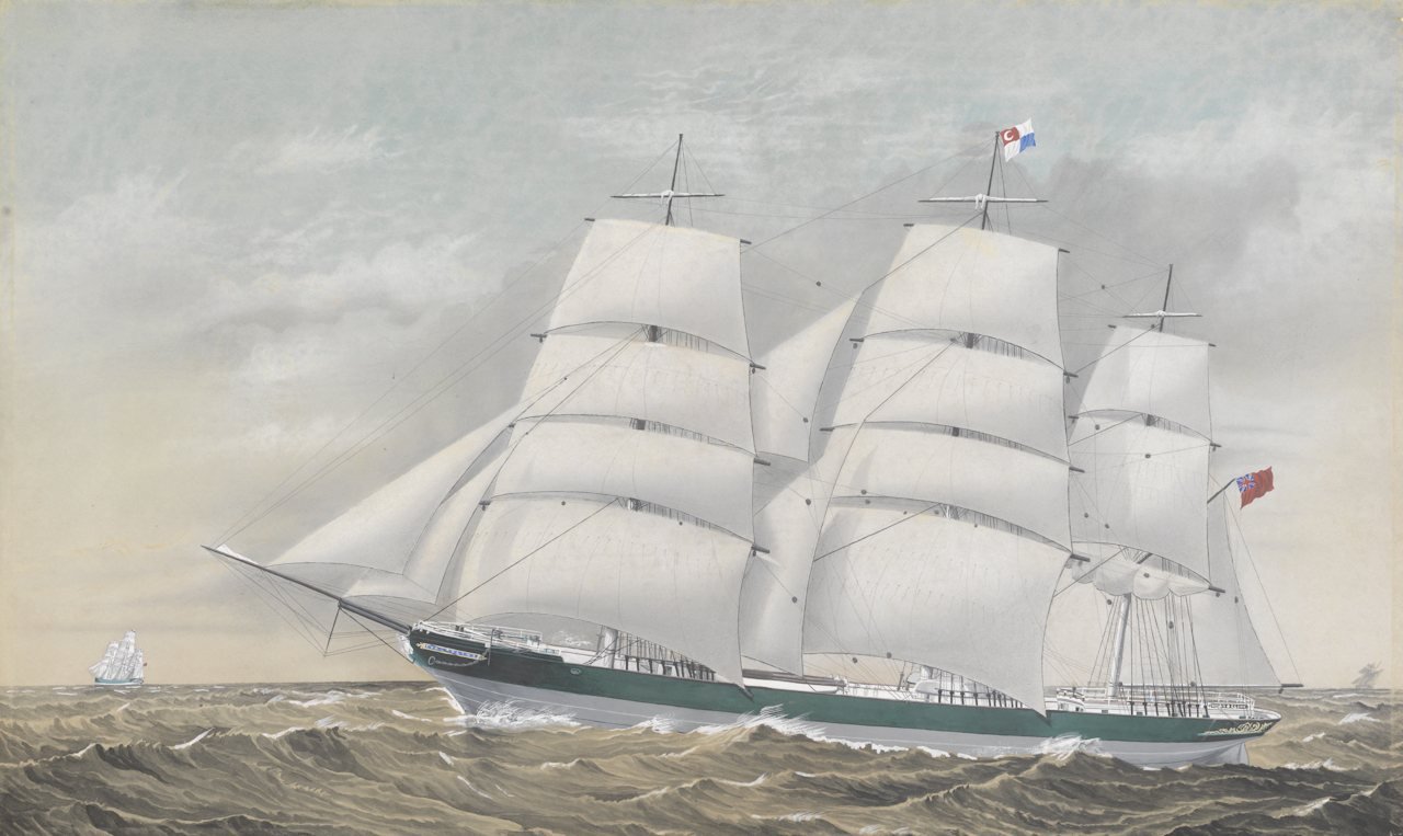
The clippers of the mid-nineteenth century were narrow, heavily canvassed ships built for speed. In trades such as tea, a fast passage could earn a premium because the first cargo to market commanded attention and price. Clippers transformed sail handling, hull form and crew discipline into a commercial weapon. They were beautiful because their economics demanded it.
They were also a warning. The clipper optimized one variable—speed under favourable wind—at the moment a competing system was learning to guarantee arrival. Steamships were initially expensive and coal-hungry, but schedule ultimately mattered more than occasional brilliance. The market moved from the fastest passage to the most predictable network.
Steam bought a timetable—and a chain of coal
Steam transformed the proposition. A vessel that could maintain a schedule was more useful to mail, passengers, high-value goods and industrial supply. Iron and then steel hulls increased size and durability. Screw propellers replaced or supplemented paddle wheels. Engines became more efficient. Refrigeration later opened intercontinental markets for meat and other perishables.
Yet the new freedom from wind created a harder dependence on infrastructure. A steamship needed bunkers, repair docks, reliable charts and access to ports controlled by friendly authorities. Coaling points from Gibraltar and Malta to Aden, Colombo, Singapore and Hong Kong became links in a strategic chain. A state that controlled the chain could support merchant traffic in peace and naval operations in war.
The map of commerce was becoming a map of fuel and information ownership.
Suez: a shortcut becomes an imperial hinge
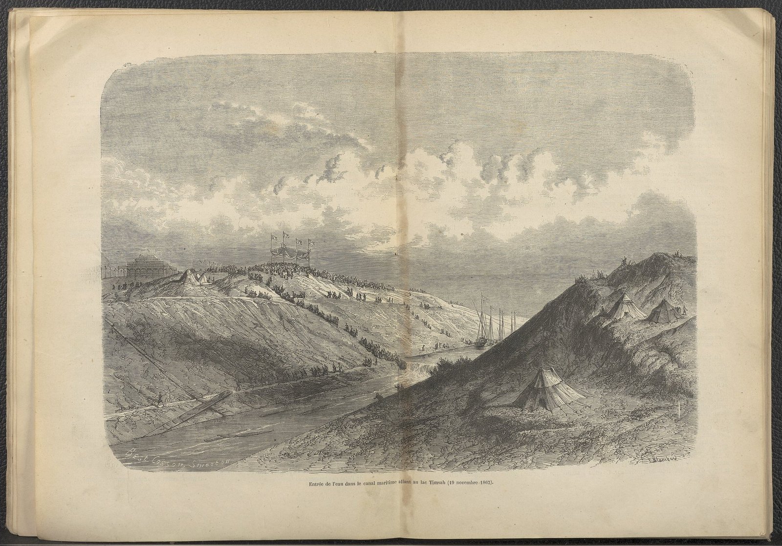
When the Suez Canal opened on 17 November 1869 after a decade of construction, it joined the Mediterranean and Red Sea without locks.[12] The route between Europe and the Indian Ocean no longer required rounding southern Africa. Distance collapsed—and with it the strategic map of empire.
The canal also reveals who pays for “frictionless” trade. Tens of thousands of Egyptians worked on the project, many under systems of forced labour before corvée was ended in 1864.[34] Egypt bore heavy financial costs. European shareholding and debt politics helped turn a commercial passage into a focus of British and French power. Britain purchased the Khedive’s shares in 1875 and occupied Egypt in 1882. The canal’s nationalization by Egypt in 1956 triggered an invasion and a geopolitical crisis.
A shortcut is never merely shorter. It redistributes rent, power and vulnerability.
Panama: engineering a gate through a state
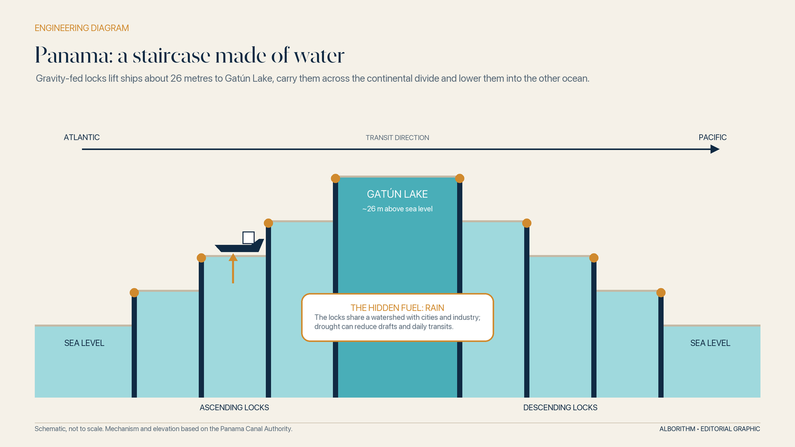
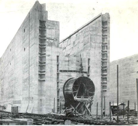
The Panama Canal, officially opened to commerce on 15 August 1914, created another artificial hinge between oceans.[13] It is best understood as a hydraulic elevator. Gravity-fed locks raise vessels about 26 metres from sea level to Gatún Lake, carry them across the continental divide and lower them into the other ocean. The project relied on excavation, railways, concrete, medical campaigns against mosquito-borne disease—and a vast multinational workforce, much of it recruited from the Caribbean under discriminatory labour systems.[35]
Its geopolitics were as engineered as its locks. The United States supported Panama’s separation from Colombia and obtained sweeping control over the Canal Zone. Panamanians spent generations contesting that arrangement. The 1977 Torrijos–Carter Treaties created the path to full Panamanian control in 1999.
Canals do not simply cut through land. They cut through sovereignty.
The Telegraph separates information from cargo
Before the cable, a merchant often learned what happened to a shipment when the ship—or news of its loss—arrived. Information travelled at transport speed.
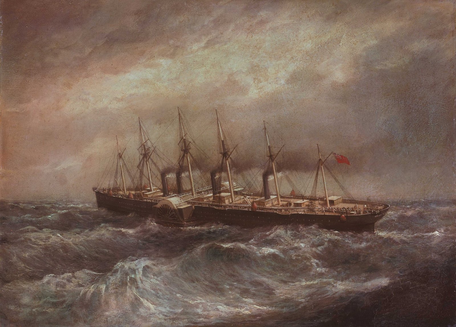
The telegraph broke that bond. The first transatlantic cable worked briefly in 1858; a durable connection followed in 1866. Messages that had taken days or weeks could cross in minutes. Prices in distant markets converged more quickly. Orders could be changed while cargo was en route. Governments and navies could direct faraway operations from imperial centres.
The new network immediately created a standards problem. Different national systems, tariffs and procedures could make a message stop at a border. In 1865, 20 states signed the first International Telegraph Convention and created the institution that became the International Telecommunication Union. They harmonized equipment, operating instructions, tariffs and accounting.[14]
That is a pattern worth remembering: every successful network eventually becomes a standards negotiation.
The invisible architecture: finance, rules and institutions
A modern cargo can cross ten jurisdictions while the seller, buyer and bank remain in three others. That is possible because the physical shipment travels inside an invisible envelope of promises.
Who owns the goods at each point? Who pays for loading? When does risk pass from seller to buyer? What counts as proof that the cargo was shipped? Which court or arbitration body decides a dispute? What currency settles the invoice? What happens if a bank will not trust the buyer, but will trust another bank’s documents?
Trade finance solves part of this by substituting institutional trust for personal familiarity. Bills of exchange allowed obligations to circulate. Letters of credit let banks promise payment against compliant documents. A bill of lading became receipt, evidence of the carriage contract and, in many systems, a document controlling delivery of the goods. Marine insurance turned a ruinous individual loss into a priced, pooled risk.
The great achievement was not eliminating uncertainty. It was making uncertainty tradable.
A rulebook made by states—and by merchants
Not all global rules are treaties. The International Chamber of Commerce first published Incoterms in 1936 to standardize the meaning of recurring sale terms: who arranges carriage, who pays which costs, where delivery occurs and where risk transfers.[15] They work because commercial parties voluntarily write them into contracts.
The World Customs Organization’s Harmonized System does something equally prosaic and profound: it gives traded goods a common classification language. More than 200 countries and economies use the six-digit system, and more than 98 per cent of internationally traded merchandise is classified through it.[16]
A container of bicycle parts can cross borders only because customs authorities agree what the parts are in administrative terms. Taxonomies move cargo.
Catastrophe writes the safety code
Maritime regulation often advanced after the sea exposed a system’s weakest promise.
The loss of the Titanic in 1912 led to the first International Convention for the Safety of Life at Sea in 1914. Later versions expanded the common floor for vessel construction, fire protection, lifesaving equipment, radio communications, navigation and cargo safety. The International Maritime Organization, formally established after its convention entered into force in 1958, became the forum where governments continuously update that floor. MARPOL addressed pollution from ships; the Container Safety Convention created a common regime for testing and approving containers; later systems standardized distress communications and security.[41]
These conventions do not make every ship equally safe, nor do they erase weak enforcement. Their deeper achievement is reciprocal recognition. A vessel cannot economically undergo a wholly new safety regime at every border. International shipping scales because port states, flag states, classification societies and insurers operate from a sufficiently common technical grammar.
That grammar also creates power. A ship’s flag determines its primary regulator. Classification societies certify key technical features. Insurers can make a voyage commercially impossible. Port-state inspectors can detain a vessel. Sanctions authorities and banks can block payment even when the sea lane itself remains open. Much of maritime power is exercised far from the bridge.
Bretton Woods and GATT: rebuilding trust after collapse
The nineteenth-century trade system expanded under empire, the gold standard and British maritime power. It also transmitted financial crises, reinforced imperial asymmetries and proved politically fragile. World War I shattered much of it. The interwar years brought debt disputes, competitive devaluations, tariffs, quotas and depression. Trade contracted inside a crisis of legitimacy.
In 1944, delegates from 44 Allied nations met at Bretton Woods to design a more stable monetary order. They created the International Monetary Fund and what became the World Bank: one to support monetary cooperation and countries facing balance-of-payments trouble, the other to finance reconstruction and development.[17]
The planned International Trade Organization never came into force. Its provisional substitute did. In 1947, 23 countries signed the General Agreement on Tariffs and Trade, combining tariff concessions with rules meant to prevent governments from cancelling those concessions through other restrictions.[18] GATT governed much of world trade until the World Trade Organization began in 1995, extending the institutional system to services, intellectual property and a stronger dispute-settlement framework.
The logic was political as much as economic. The architects of the post-war order believed destructive economic nationalism had helped prepare the ground for conflict. Rules would not end power politics, but they could create a repeated game in which retaliation was not the only response.
The institutions inside one ordinary shipment
| Layer | What it does | Examples |
|---|---|---|
| Monetary stability | Makes currencies and external payments more predictable | IMF, central banks, correspondent banking |
| Market access | Sets tariff commitments and non-discrimination rules | GATT/WTO, regional trade agreements |
| Product identity | Gives customs a shared language for goods | WCO Harmonized System |
| Commercial allocation | Defines delivery, cost and risk between buyer and seller | ICC Incoterms, sale contracts |
| Payment assurance | Exchanges documents and bank promises for payment | Letters of credit, UCP rules, correspondent banks |
| Vessel safety and pollution | Establishes common minimum rules for international shipping | IMO, SOLAS, MARPOL |
| Container safety and dimensions | Makes the box acceptable across borders and modes | ISO standards, 1972 CSC |
| Border execution | Clears the real cargo | National customs, port and health authorities |
The International Maritime Organization’s convention entered into force in 1958. Its work turned earlier maritime conventions into an evolving global rule set for safety, navigation and pollution.[19] These rules are imperfect and enforcement varies, but their universality matters. A ship is useful only if foreign ports accept its certificates, crew documents, safety equipment and cargo declarations.
Globalization is often described as deregulation. In practice, deep globalization required an extraordinary amount of regulation—not identical national laws, but enough compatibility to keep handoffs from breaking.
1956: the box that reorganized the shore
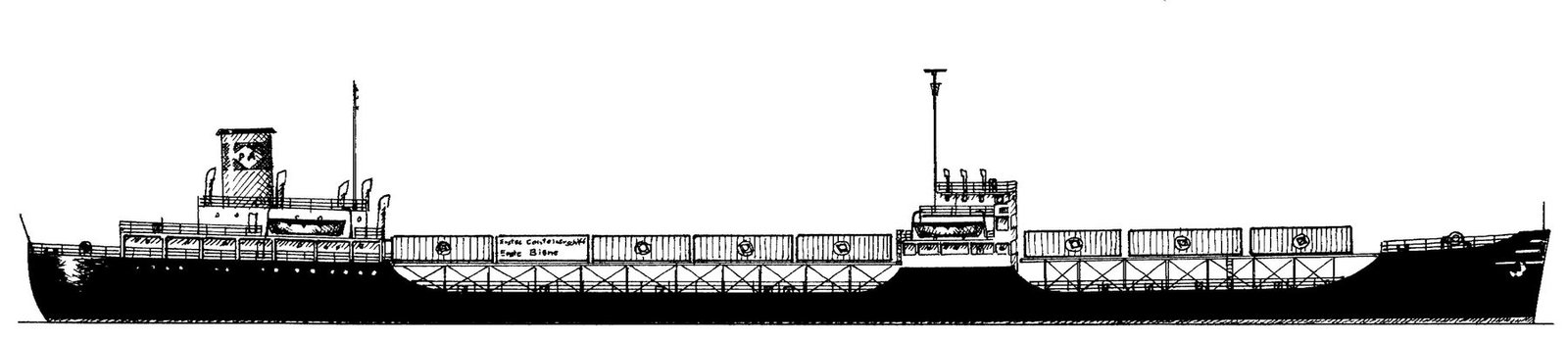
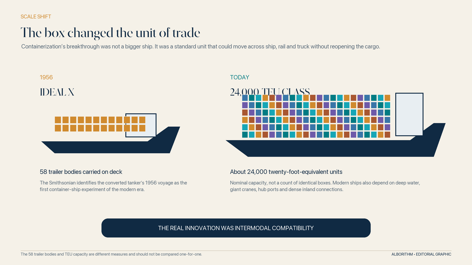
On 26 April 1956, the converted tanker Ideal X sailed from Newark to Houston carrying 58 loaded trailer bodies on its deck. The experiment associated with trucking entrepreneur Malcom McLean is widely treated as the beginning of modern container shipping.[20]
Containers already existed. McLean’s decisive insight was systemic: cargo should move from truck to ship to rail without being unpacked and handled piece by piece at every transfer.
The old port was labour-intensive and intimate. Longshore workers lifted barrels, sacks, crates, machinery and boxes of different dimensions into the hold, then secured them by judgement and experience. Loading could take days. Cargo was exposed to weather, theft, breakage and paperwork errors. The ship waited while the port worked.
The standardized container converted those irregular objects into one machine-readable unit.
Standardization, not steel, made the revolution
A private design becomes a global network only when competitors can build to the same interface. The American Standards Association created a cargo-container committee in 1958; ISO formed its freight-container technical committee in 1961.[21] Dimensions, corner fittings, strength tests, markings and handling conventions made boxes compatible with ships, cranes, rail wagons and trucks built by unrelated companies in different countries.
In the 1960s, container use and specialized container ships expanded rapidly. The 1972 International Convention for Safe Containers created common testing and approval rules, allowing an approved box to move internationally with minimal repeated safety formalities.[22]
That small metal corner casting may be one of the most consequential designs in economic history. A crane in Shanghai, a wagon in Kazakhstan and a truck chassis in Rotterdam can all grip the same standardized points.
The container did not merely speed up the port. It reorganized geography:
- Warehouses moved away from expensive waterfront land.
- Rail terminals and motorways became part of the port.
- Old finger piers became obsolete; vast terminals required deep water and acres of storage.
- Manufacturing could fragment across borders because intermediate goods became cheaper and more reliable to move.
- Port labour shifted from large gangs handling mixed cargo to smaller teams operating capital-intensive equipment, creating fierce disputes over jobs and compensation.
- Ports that could not finance dredging, cranes, land and digital systems risked falling off mainline routes.
The box was neutral in shape but not in effect. It rewarded scale, capital and connectivity.
From container ships to megaships
Once cargo had a standard unit, ship economics pushed toward scale.
A larger vessel can spread crew, fuel and capital costs across more boxes, reducing cost and emissions per container when it is well utilized. Hulls widened. Ports deepened channels. Cranes reached farther. Carriers organized hub-and-spoke networks in which very large ships serve a limited number of major ports and feeder vessels distribute containers onward.
By the early 2020s, the largest ships had moved into the 24,000-TEU class. MSC’s Michel Cappellini, for example, is 400 metres long, 61.5 metres wide and rated at up to 24,346 TEU.[23]
But economies of scale at sea can create diseconomies on land.
When a megaship arrives, thousands of boxes enter the terminal plan at once. Cranes, yard space, customs, trucks, rail slots and warehouses must absorb a surge. Fewer ports can accommodate the vessel. Each call concentrates more inventory in one hull. Schedule disruption spreads across alliance networks. The ship saves money only because ports, public authorities and inland operators invest to serve it.
Scale also interacts with market power. UN Trade and Development reported that the capacity of the largest container ships more than doubled between 2006 and 2022, while the top 20 carriers’ share of container capacity rose from 48 per cent in 1996 to 91 per cent in 2022.[24] Bigger ships and carrier consolidation are not identical phenomena, but they reinforce a network in which fewer firms and ports coordinate larger flows.
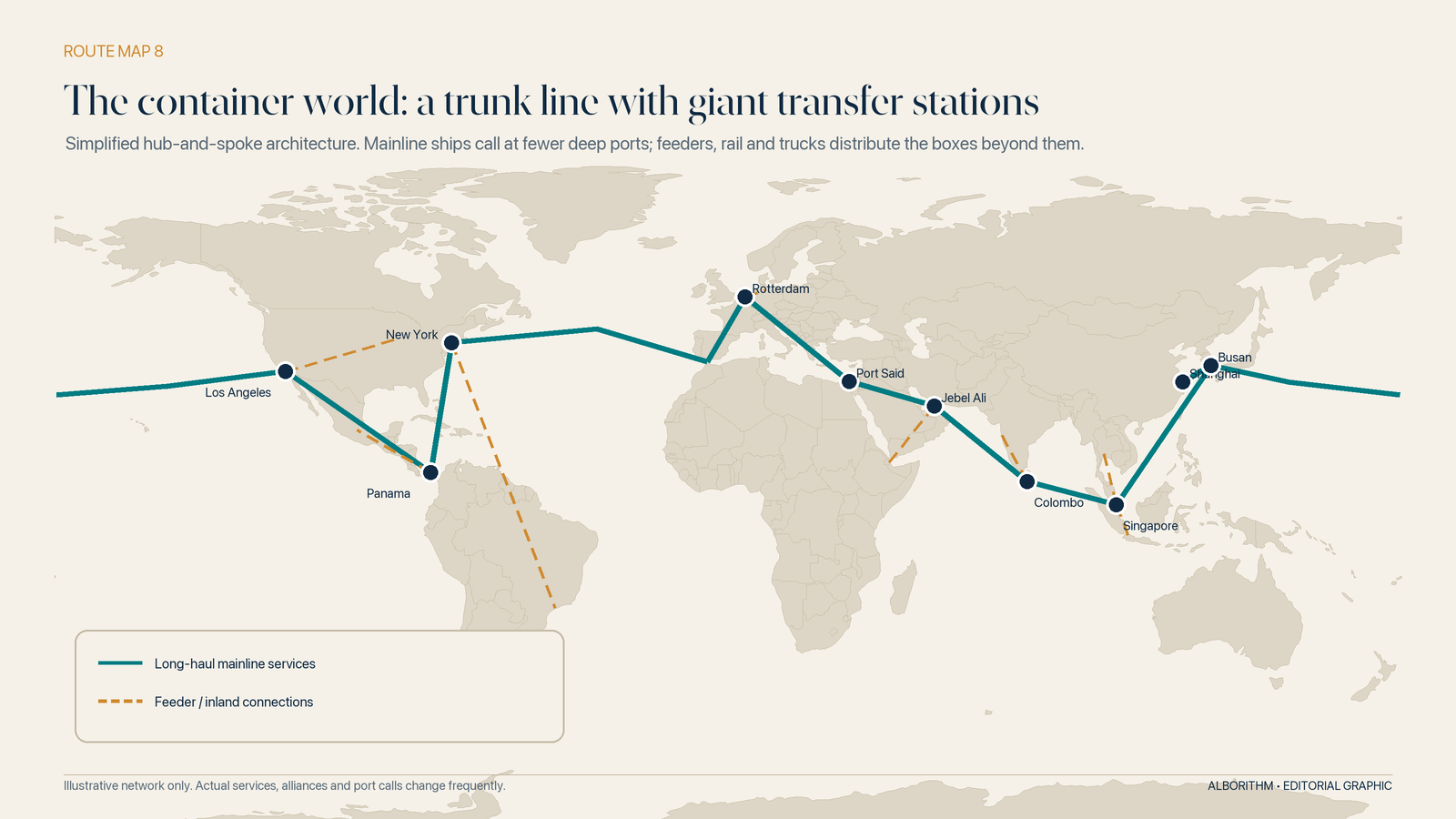
This is the megaship bargain: lower unit cost in normal conditions, higher consequence when normal conditions fail.
Chokepoints: the narrow doors of a global system
Look at a world map and the oceans appear open. Look at commercial routes and they contract into corridors.
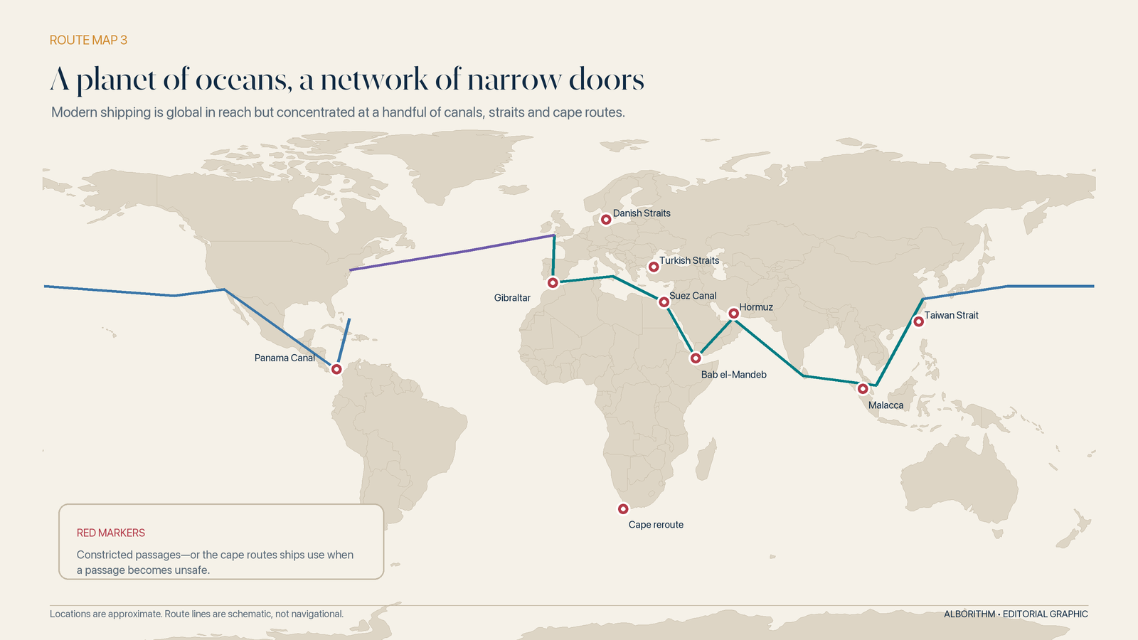
Ships follow coastlines, fuel economics, port rotations, weather patterns, canal dimensions, security advice and cargo demand. The resulting network funnels through straits and artificial cuts. These are chokepoints not because passage is always blocked, but because practical alternatives impose significant distance, time or risk.
Suez and Bab el-Mandeb: one corridor, two gates
Suez connects the Mediterranean to the Red Sea; Bab el-Mandeb connects the Red Sea to the Gulf of Aden. Together they form the shortest main sea route between Asia and Europe.
Before the recent Red Sea disruptions, the Suez Canal handled roughly 10 per cent of global maritime trade volume and about 22 per cent of world container trade.[25] But a canal cannot deliver strategic value if the approach to it is unsafe. Attacks on shipping in and around the Red Sea pushed many vessels around the Cape of Good Hope. By May 2025, tonnage through Suez remained about 70 per cent below the 2023 average.[26]
The decisive variable was confidence. A navy can intercept threats and an insurer can name a war-risk premium, but a carrier still has to believe that a ship, crew and schedule face an acceptable probability of harm. Modern shipping converts confidence into timetables; when confidence disappears, distance returns.
One threatened segment devalued the entire shortcut.
Hormuz: energy’s pressure valve
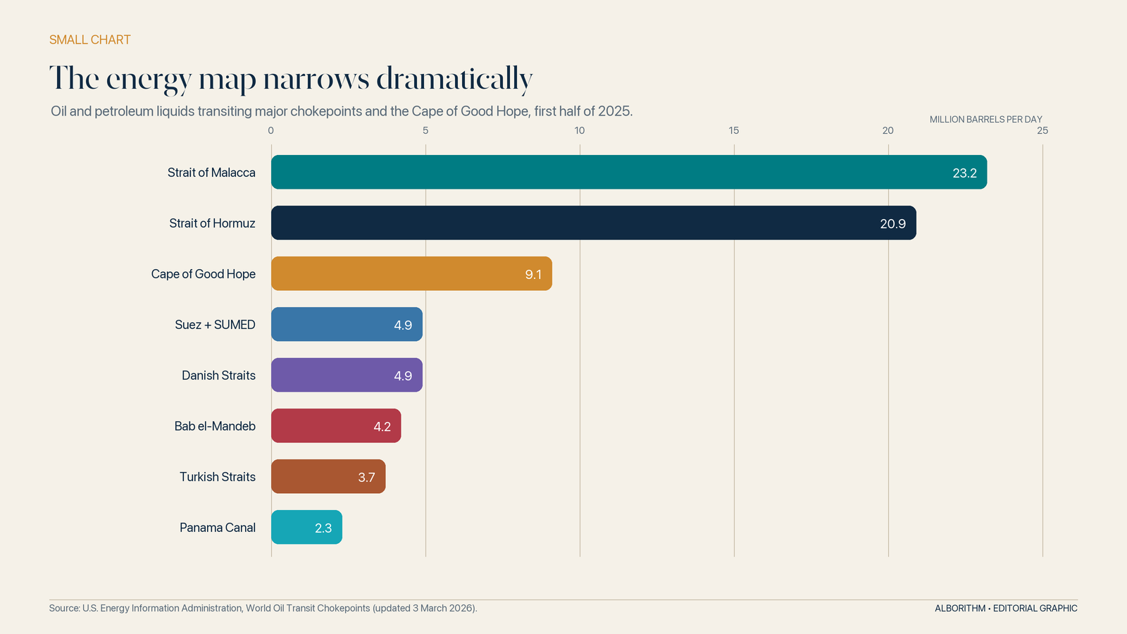
The Strait of Hormuz is the outlet of the Persian Gulf and one of the world’s most consequential energy passages. The U.S. Energy Information Administration estimated that 20.9 million barrels per day of petroleum and other liquids moved through it in the first half of 2025. The Strait of Malacca carried even more—23.2 million barrels per day—because it funnels flows between the Indian and Pacific Oceans.[27]
Pipelines can bypass some maritime exposure, and strategic reserves can cushion a temporary shock. Neither fully replaces the straits at current scale.
Malacca: Asia’s compressed geography
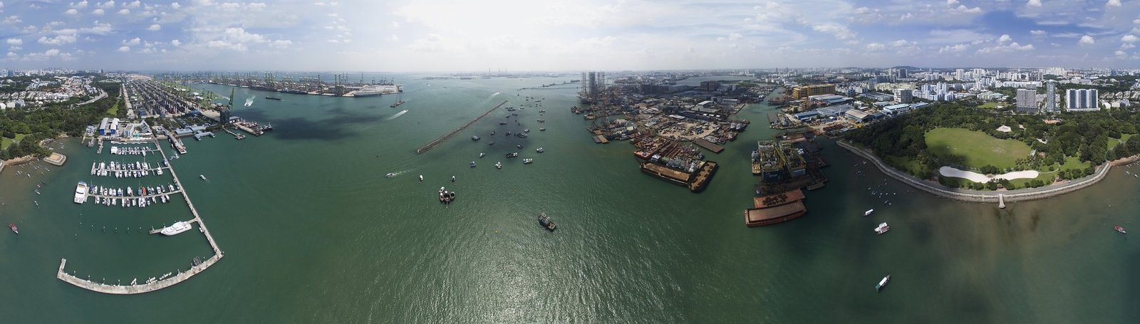
The Strait of Malacca lies between the Malay Peninsula and Sumatra, linking the Indian Ocean to the South China Sea. It sits between major energy exporters to the west and manufacturing centres to the east. Singapore’s rise as a port, refinery, finance centre and maritime-services hub is inseparable from this geography.
Alternatives exist through the Sunda and Lombok straits, but “alternative” does not mean equivalent. Deeper or longer passages change fuel consumption, insurance, schedules and vessel deployment.
Panama: a chokepoint whose fuel is rain
Panama’s lock system depends on fresh water. Each transit competes within a watershed also serving communities and industry. During severe drought, the Panama Canal Authority reduced daily transits and draft limits, forcing some cargo to wait, move by rail across the isthmus, take another route or carry less.
The lesson is larger than Panama: infrastructure designed around historical climate ranges is now part of climate geopolitics. A canal can be strategically secure and physically intact, yet constrained by rainfall.
Turkish and Danish straits: inland seas meet the world
The Bosporus and Dardanelles connect the Black Sea to the Mediterranean. Their importance rises sharply when grain, fertilizer and energy exports from Black Sea ports are disrupted. The Danish straits connect the Baltic to the North Sea, while Gibraltar controls the natural gateway between the Mediterranean and Atlantic.
Not every chokepoint carries the same cargo. That is why volume alone can mislead. A passage carrying a smaller share of total tonnage may dominate one commodity, one region’s food security or one military calculation.
What the Ever Given made visible
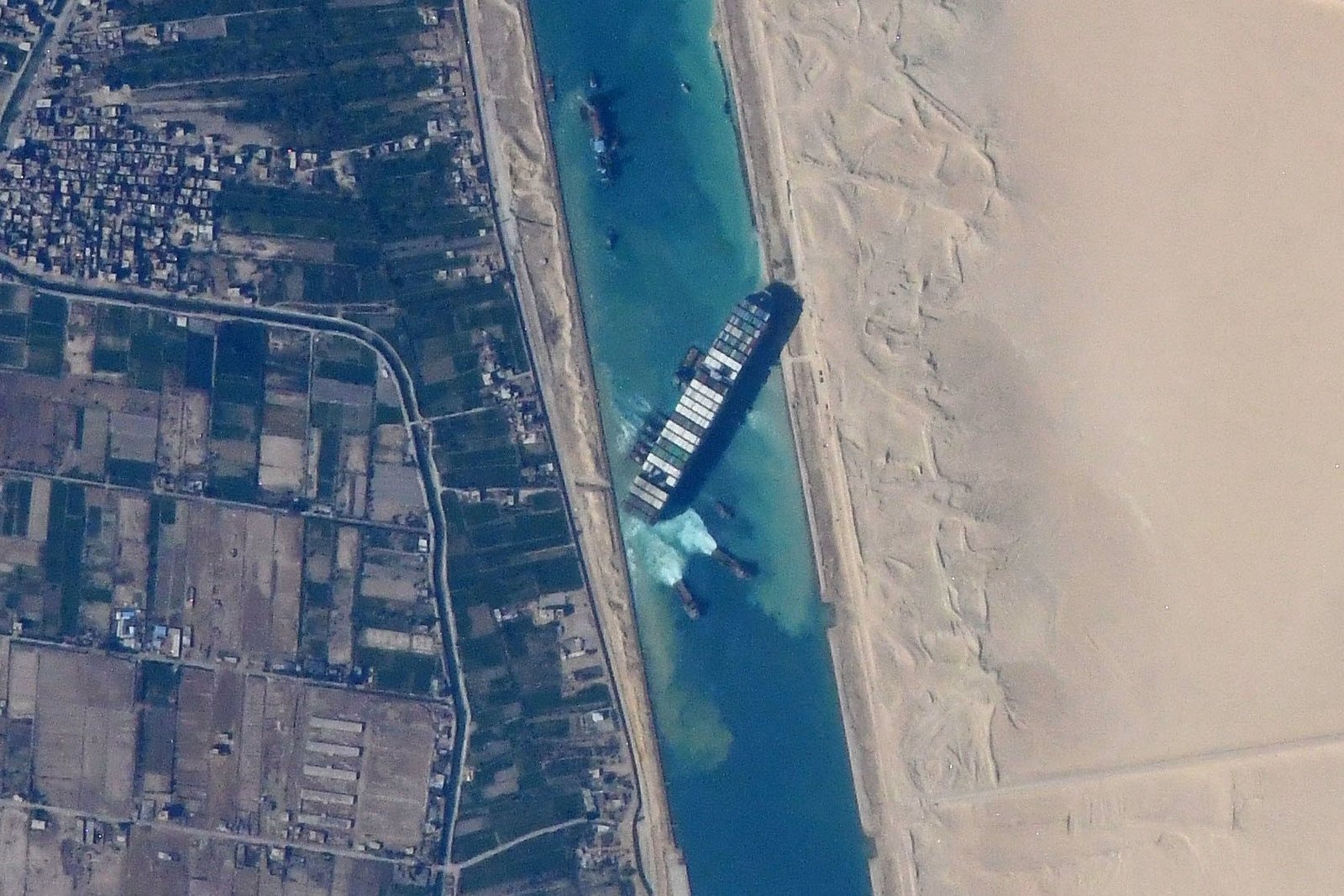
On 23 March 2021, the 400-metre container ship Ever Given ran aground across the Suez Canal. From orbit, the vessel looked almost delicate: a narrow line of containers lodged diagonally in a pale strip of water.
For six days, it blocked one of the world’s busiest trade arteries.
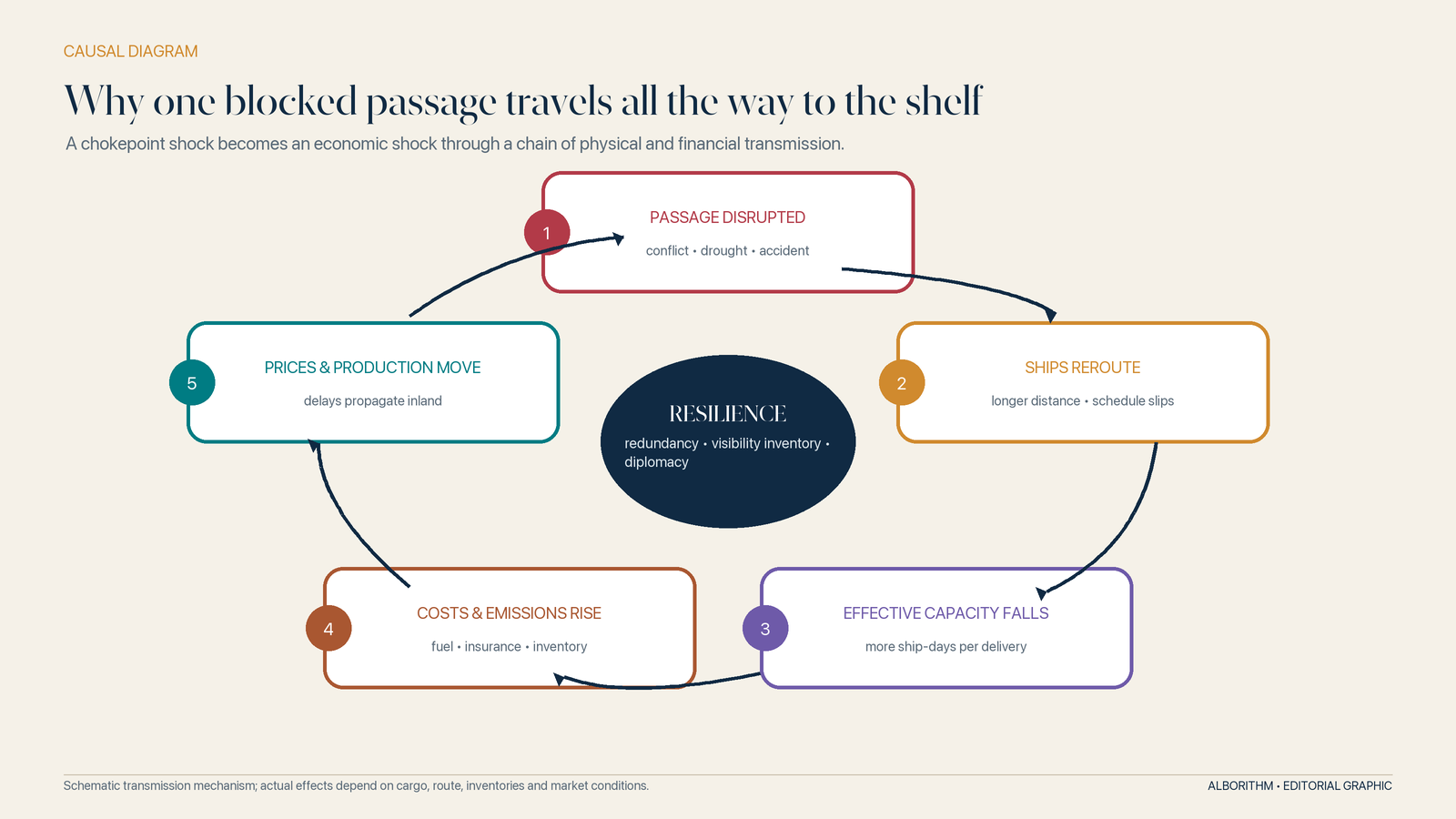
The spectacle invited jokes, but the economics were serious. Vessels queued at both entrances. Carriers debated whether to wait or reroute around Africa. Cargo owners lacked clear arrival dates. Insurers confronted claims. Ports prepared for bunching when delayed ships finally arrived together.
The incident showed that supply chains are not chains. They are synchronized networks. Delay at one link does not pass downstream neatly; it changes the timing of many links at once.
The Red Sea crisis later proved an even deeper point. The system can clear an accidental obstruction with dredgers and tugs. It cannot engineer its way quickly out of sustained geopolitical danger.
The Geopolitics inside a shipping label
A ship has a flag, an owner, an operator, a builder, a classification society, an insurer, a lender, a crew and a cargo. These may be connected to nine different countries.
That fragmentation is not a paperwork curiosity. It is the political architecture of the fleet.
At the start of 2026, the global merchant fleet comprised roughly 116,000 vessels of at least 100 gross tons. Greece, China and Japan were the largest locations of beneficial ownership by carrying capacity. Liberia, Panama and the Marshall Islands were the three largest ship registries; together with Singapore and Hong Kong, the five largest registries accounted for 58 per cent of global capacity. Meanwhile, 91 per cent of gross tonnage completed in 2025 was built in China, South Korea or Japan.[28]
Ownership is concentrated one way, registration another, construction a third. Insurance, reinsurance, classification and maritime law create still more layers. A sanction applied to finance or insurance can immobilize a vessel without a warship ever approaching it. A port-state control action can detain it. A flag state can determine which rules are enforced. A naval escort can change the risk calculation on an entire corridor.
The sea may look stateless. Shipping is saturated with jurisdiction.
The modern brokers: who can make a ship move—or stop it
Imagine a captain approaching a threatened strait. The helm is on the bridge, but the decision is distributed across the world.
The carrier’s operations centre weighs schedule and customer commitments. The shipowner protects the asset. Charterers interpret the contract. Security advisers read threat intelligence. Hull and machinery insurers consider physical damage; protection-and-indemnity clubs consider liabilities to crew, cargo and third parties. A classification society’s status affects whether the vessel is trusted. The flag state supplies the legal identity. Coastal and port states control passage and entry. Banks screen payments. Sanctions authorities define prohibited counterparties. Naval commanders shape the danger without controlling the commercial calculation.
If any critical actor says no, a technically seaworthy ship may not sail.
| Power broker | What it controls | Its leverage over the route |
|---|---|---|
| Shipowner and carrier | Vessel, schedule and customer network | Can deploy, delay, omit a port or reroute the service |
| Terminal operator and port authority | Berth, cranes, depth, gate and local rules | Can accelerate a call—or leave the ship waiting offshore |
| Flag state and classification society | Legal identity and technical certification | Determine whether certificates are credible and current |
| Insurer, P&I club and lender | Financial permission to take risk | Can price a voyage beyond viability or withhold cover and finance |
| Customs, sanctions and security authorities | Legal permission for cargo and counterparties | Can detain, seize, exclude or block payment |
| Navy and coastal state | Physical security and passage conditions | Can deter attack, restrict access or alter the strategic balance |
This is why modern sea power is no longer only a matter of fleets. It also resides in registries, balance sheets, databases, standards bodies, terminal concessions and the ability to declare a counterparty too risky to touch.
Ports as strategy
Ports are no longer just sheltered water and a quay. A competitive container port is a capital-intensive interface: deep channel, long berths, ship-to-shore cranes, yard automation, customs integration, reliable power, cybersecurity, road and rail capacity, and enough nearby industrial or consumer demand to sustain services.
This makes port investment geopolitical. China’s Belt and Road Initiative, announced in 2013, put transport corridors, railways, ports and logistics zones inside a transcontinental state strategy. World Bank research found that corridor projects could reduce shipment time and trade costs, while emphasizing that gains depend on transparency, debt sustainability, border reform and complementary policies.[29]
Other powers have responded with their own corridor plans, infrastructure finance, export controls, investment screening and “trusted” supply-chain partnerships. Ports, submarine cables, data centres, rail gauges, payment systems and technical standards have become arenas of strategic competition.
Trade is rewiring, not simply retreating
The shocks of the 2020s produced a vocabulary of retreat: reshoring, nearshoring, friendshoring and decoupling. Some production is moving. Governments are willing to pay more for domestic or politically aligned capacity in semiconductors, batteries, energy, pharmaceuticals and defence-related goods.
But “deglobalization” is too simple. Supply chains can become more geopolitical while remaining deeply international. A factory may move from one foreign supplier to another. Goods may travel through a connector economy. Companies may add suppliers rather than abandon the original one.
UN Trade and Development found friendshoring indicators above their 2021 averages in early 2025, alongside increasing diversification and declining nearshoring in recent quarters.[30] The 2025 Global Value Chain Development Report found that the share of value-chain trade declined only modestly, from a 2022 peak of 48 per cent to 46.3 per cent in 2024.[31]
The emerging system is not less connected so much as more conditional. Cost still matters. So do security, subsidy, carbon exposure, political alignment, data control and resilience.
The digital twin of the container
The physical box solved one interface problem. Its paperwork remains fragmented.
An international shipment can generate purchase orders, invoices, packing lists, certificates of origin, export declarations, security filings, dangerous-goods declarations, bills of lading, inspection records and import entries. Some are still exchanged as paper or PDFs among systems that do not share data cleanly.
Digital trade infrastructure is trying to give the cargo a reliable identity that travels with it: electronic bills of lading, port community systems, customs single windows, sensor records, satellite positioning, automatic identification system data and standardized application interfaces.
The value is not simply “paperless trade.” It is synchronization. If a port knows earlier what will arrive, it can plan cranes and yard slots. If customs receives structured data before arrival, it can target inspections. If a bank can trust an electronic original, payment can move without waiting for couriered documents.
But digitalization adds another layer of dependence. A port community system can become a single point of failure. False cargo data can move faster. Ransomware can stop gates. Cybersecurity, identity standards and legal recognition become as essential as dredging.
The container has acquired a digital twin—and that twin now needs its own law, locks and watchmen.
Who pays for speed?
The architecture of global trade is often judged by throughput: tonnes, boxes, vessel calls, dwell time, freight rates. Those metrics reveal efficiency. They can hide distribution.
A fast port may depend on precarious trucking labour. A low freight rate may omit pollution borne by communities near shipping lanes and terminals. A rerouted vessel may protect its crew from attack while adding fuel burn and emissions. A just-in-time factory may save inventory cost by transferring the risk of interruption to suppliers with less bargaining power.
Developing countries and island economies are especially exposed. They often pay higher transport costs, receive fewer direct services and possess less leverage over carriers. When routes lengthen, a low-value export can become uneconomic before a high-value import does. UNCTAD repeatedly warns that shipping disruption falls hardest on economies least able to absorb it.[26]
Even port efficiency is unevenly produced. The World Bank’s Container Port Performance Index measures vessel time in port because minutes at berth propagate through network schedules. Its data show high-performing ports across regions, but also the scale of investment and coordination required to remain connected.[32]
The right question is not whether trade creates value. It plainly does. The right question is who captures the savings, who finances the infrastructure and who carries the tail risk.
The next architecture: from maximum efficiency to managed resilience
For three decades, the dominant design principle was optimization: larger ships, fewer suppliers, lower inventory, faster turns, tighter schedules. The shocks of the 2020s did not abolish efficiency. They exposed the cost of pursuing it without slack.
The next trade architecture is likely to be built around five changes.
1. Redundancy becomes an asset
Companies are mapping sub-tier suppliers, qualifying alternatives and holding more strategic inventory. Governments are financing reserve capacity in sectors they consider critical. Ports and carriers are planning reroutes before a crisis begins.
Redundancy costs money in calm periods. That is what makes it redundancy. The challenge is to distinguish sensible insurance from permanent protection for inefficient incumbents.
2. Corridors become greener—and more contested
Shipping’s energy transition is not a simple engine swap. Methanol, ammonia, hydrogen-derived fuels, sustainable biofuels, batteries and wind assistance have different storage, safety and infrastructure needs. A vessel ordered today may operate for decades, while future fuel availability and prices remain uncertain.
The International Maritime Organization’s 2023 strategy aims for net-zero greenhouse-gas emissions from international shipping “by or around” 2050, with indicative reductions of at least 20 per cent by 2030 and 70 per cent by 2040 from 2008 levels, while striving for deeper cuts.[33] Meeting that goal requires global fuel standards, production, bunkering corridors, safety rules and financing—not merely more efficient hulls.
The transition could redraw the map. Ports able to supply future fuels may gain hub status. Countries with abundant renewable energy may export molecules as well as electricity. Carbon pricing can alter route economics. Green standards can become tools of cooperation or new barriers.
3. Climate enters the engineering specification
Sea-level rise, extreme heat, storms, river flooding, drought and sedimentation will affect ports and canals differently. Cranes, power systems, access roads, warehouses and worker-safety rules will need to adapt. The Panama Canal’s water constraints are an early warning that resilience belongs at watershed scale, not only inside the port fence.
4. Visibility improves, but prediction remains political
AI can forecast arrival times, identify congestion and match inventory to alternative routes. Sensors can reveal temperature excursions and tampering. Digital documentation can reduce delay.
None can predict a government’s escalation with the confidence of a tide table. Better data shorten reaction time; they do not remove politics from trade.
5. The system becomes more regional without becoming regional only
Some production will move closer to demand. Some will move toward allies. Yet resources, labour pools, industrial clusters and consumer markets remain unevenly distributed. The likely outcome is a layered network: regional production for some goods, global sourcing for others, and strategic reserves for a narrow category of essentials.
The decisive firms and states will not choose between globalization and autarky. They will decide which connections must be cheap, which must be secure and which must be duplicated.
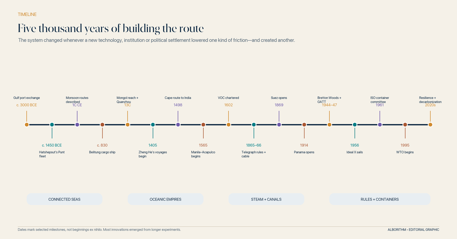
A 5,000-year timeline of global trade routes
The route is a promise
Stand again beside the megaship.
Its engines, hull and containers are feats of engineering. But the vessel can sail only because millions of strangers expect other strangers to do what a network requires.
A factory expects a truck. The truck expects a gate slot. The terminal expects a customs release. The crane expects a box built to tolerance. The captain expects a safe depth. The canal expects a booking. The buyer expects documents. The bank expects compliance. The insurer expects disclosure. The port expects the ship’s certificates to be recognized. Every handoff is a promise backed by a mixture of code, contract, habit, institution and power.
That was true when a Sogdian merchant entered a caravanserai. It was true when a dhow waited at Zanzibar for the monsoon. It was true when a Manila galleon loaded silver, when a steamship coaled at Aden, when a telegraph operator handed a message across a border and when the Ideal X lifted trailer bodies onto its deck.
What changed was the number of promises that could be stacked—and the distance over which they could be trusted.
The architecture of global trade is therefore not the megaship, the canal or the container. It is the arrangement that makes all three usable together. Its deepest strength is interoperability. Its deepest weakness is that interdependence can be weaponized, interrupted or made unjust.
Humanity did not conquer distance. It built a system that negotiates with distance every day.
And every morning, before the first crane lifts the first box, that negotiation begins again.
The Great Maritime Decoupling: Scaling a Fossil-Free Engine for Global Trade
1. Introduction: The Invisible Engine of the World
Take a moment to consider the device you are holding or the chair in which you sit. Statistically, there is a 90% chance that these items—and almost every other physical component of your life—spent time in a container on the open ocean. This is the “invisible engine” of our world: a massive network of 100,000 commercial vessels that forms the backbone of global trade.However, this engine is currently running on a legacy of carbon. These vessels consume approximately 300 million tons of fuel annually, contributing around 3% of global carbon emissions. Because of the immense energy density required for transoceanic voyages, shipping is a quintessential “hard-to-abate” sector. Decarbonizing it is not a matter of simple adjustment; it is an industrial moonshot that requires a total re-engineering of global logistics.
2. The 183 Million Tonne Ammonia Challenge
A central pillar of this transition is the unprecedented scaling of renewable e-ammonia. Analysis by the International Renewable Energy Agency (IRENA) projects that international shipping will require a staggering 183 million tonnes of renewable ammonia by 2050.This requirement is profoundly counter-intuitive. It means that by mid-century, the shipping industry alone will consume a volume of ammonia comparable to today’s entire global production for all combined industrial and agricultural uses.The industry is not just changing a fuel source; it is re-engineering the chemical foundations of the world. This represents a total pivot from ammonia’s traditional role as a fertilizer component to its new status as a primary energy carrier for global trade.”Renewable e-ammonia will play a pivotal role; where 183 million tonnes of renewable ammonia for international shipping alone will be needed by 2050 – a comparable amount to today’s ammonia global production.” — IRENA
3. The Two-Speed Strategy: Efficiency Now, Hydrogen Later
Navigating the 2050 deadline requires a two-speed strategy that bridges the gap between today’s fossil-fuel reliance and tomorrow’s green hydrogen backbone.
- The Efficiency Bridge: Immediate adoption of energy efficiency measures is not merely a buzzword; it is a strategic imperative. Efficiency gains buy critical time for new fuel technologies to mature and, more importantly, aggressively reduce the total volume of expensive renewable fuel that will eventually be required.
- Short-Term Alternatives: Advanced biofuels must play the primary role in the coming years. They serve as the only immediate, “drop-in” alternatives to fossil fuels while the infrastructure for more complex energy carriers is built.
- The Long-Term Backbone: In the medium and long term, green hydrogen-based fuels will become the permanent infrastructure of the sector.
4. From Cost Penalty to Market Shield
The industry must move beyond the narrow view of renewable fuels as a “cost penalty.” Instead, we must recognize this transition as a strategic decoupling from the volatility of the fossil fuel era.Future Economic Stability While production costs for green fuels are currently high, they are projected to become cost-competitive within decades. Investing in this transition now serves as a long-term insurance policy for global supply chains.Strategic Market Protection Transitioning to renewable energy allows the maritime sector to achieve a level of price predictability that is impossible in an oil-based economy. By moving to green hydrogen and e-ammonia, the industry can shield the shipping sector from the geopolitical shocks and extreme price fluctuations that define the fossil fuel market.
5. Radical Collaboration: Beyond the Hull of the Ship
Shipping cannot decarbonize in a vacuum. Insights from the Global Centre for Maritime Decarbonisation (GCMD), the Mærsk Mc-Kinney Møller Center for Zero Carbon Shipping, and AD Ports Group emphasize that “radical collaboration” is the only path forward.Decarbonization requires “clusters”—strategic partnerships involving energy-intensive industries, power suppliers, and the petrochemical sector. This systemic change is essential to remove market uncertainties and de-risk the massive investments required for new fuel production.”The Mærsk Mc-Kinney Møller Center for Zero Carbon Shipping is real climate action. We are a not-for-profit, independent research and development center looking to accelerate the transition towards a net-zero future for the maritime industry. With our partners, we drive and facilitate the development and implementation of new technologies; build confidence in new concepts and mature viable strategic ways to drive the required systemic and regulatory change.” — Mærsk Mc-Kinney Møller Center for Zero Carbon Shipping
6. The Rise of Smart Infrastructure and AI
The evolution of green shipping is an information-driven revolution. Organizations like AD Ports Group are already integrating “Human-AI teams” into the maritime blueprint, ensuring that digital precision manages the complexities of a new energy landscape.Smart infrastructure is the prerequisite for this transition. Khalifa Port, the first semi-automated port in the region, serves as a model for how “Digital Clusters” increase productivity and real-time data access. These advanced hubs are necessary to manage the lower energy densities of future fuels, utilizing AI to optimize logistics with a level of precision that human operators alone cannot achieve.
7. Conclusion: Navigating the Great Transition
The 1.5°C pathway for the maritime industry is not just a theoretical ambition; it is a viable reality. However, achieving it by 2050 demands immediate regulatory reform and a systemic shift in how we value energy and infrastructure.As we move toward a zero-carbon horizon, we must confront our individual roles in this global network. When you look at the goods in your home today, ask yourself: how much of your world is currently floating on the ocean, and are you ready for the journey to leave no trace behind?
Frequently asked questions about global trade
When did long-distance ocean trade begin?
Long-distance maritime exchange is thousands of years older than modern globalization. By the third millennium BCE, Gulf routes linked Mesopotamia with Dilmun, Magan and the Indus world. Egyptian expeditions used the Red Sea, while Mediterranean and later monsoon networks connected expanding zones of trade. These were not one integrated world market, but they created the port, ship, tax and brokerage patterns on which later systems grew.
Why should we speak of Silk Roads in the plural?
There was no single continuous road from China to Europe. Goods moved through changing combinations of caravan tracks, rivers, mountain passes, oasis towns and maritime routes. Most merchants covered a segment rather than an entire continent. “Silk Roads” better captures the relay network—and the fact that spices, horses, metals, ceramics, faiths, technologies and disease travelled alongside silk.
What were the most important historical global trade routes?
The most influential were not single roads but interacting networks: the land and maritime Silk Roads; the Indian Ocean monsoon routes; Mediterranean and Red Sea corridors; trans-Saharan caravan routes; the Portuguese Cape route; Atlantic imperial and slave-trading routes; and the Manila–Acapulco galleon route. In the industrial era, Suez, Panama, railways and steamship lines reorganized these older geographies.
Why are maritime Chokepoints so important to global trade?
Chokepoints concentrate high-volume shipping into narrow passages where practical alternatives are longer, costlier or less suitable. The Suez Canal, Strait of Hormuz, Bab el-Mandeb, Strait of Malacca, Panama Canal, Turkish straits and Danish straits matter because disruption changes distance, effective fleet capacity, insurance, energy flows and delivery schedules across entire networks.
How did containerization change world trade?
Containerization standardized the cargo unit. Goods could move between ship, rail and truck without repeated unpacking, reducing handling time, loss and uncertainty. The larger effect was organizational: ports, warehouses, factories and inland transport were rebuilt around the box, enabling more complex global value chains.
What institutions govern international trade?
No single institution governs it. The WTO sets multilateral trade rules; the IMF supports monetary cooperation; the World Bank finances development; the IMO sets global shipping rules; the WCO maintains the Harmonized System for classifying goods; ISO standardizes technical interfaces such as containers; and the ICC publishes widely used private commercial rules such as Incoterms. National governments, courts, customs authorities, banks and insurers execute the system.
Who really controls global shipping?
Control is distributed. Shipowners and carriers deploy vessels; port and terminal operators control critical infrastructure; flag states and classification societies underpin certification; customs and sanctions authorities control legal access; insurers and lenders can make a voyage financially impossible; and coastal states and navies shape physical security. The result is not a single ruler of the seas but an interlocking field of public and private power.
Is globalization ending?
The evidence points more toward rewiring than collapse. Some trade is shifting toward politically aligned or diversified suppliers, and strategic sectors face more controls. Yet global value chains remain large, sea trade remains essential and many “reshored” systems still depend on foreign materials, equipment or markets. The emerging architecture is more security-conscious, regional in selected layers and still globally interconnected.
What is a TEU?
TEU means twenty-foot equivalent unit, the standard measure of container capacity. One 20-foot container equals one TEU; a common 40-foot container equals two TEU. A ship’s TEU figure is nominal capacity, not a guarantee that it carries that many identical boxes or that every slot is filled.
Selected sources and methodology
This article uses institutional histories, museum collections, official statistics and specialist research. Route maps are schematic syntheses: they show the architecture of exchange, not a navigational track or a claim that every route operated at the same intensity in every century. Historical images are public-domain or openly licensed works, with source and licence links in their captions. Contemporary data were checked against sources available through 4 September 2026.
- UN Trade and Development, Review of Maritime Transport 2025. UNCTAD describes maritime transport as carrying around 80 per cent of the volume of international trade in goods.
- UN Trade and Development, Key Statistics and Trends in International Trade 2025, published May 2026.
- UNESCO, “About the Silk Roads”.
- UNESCO World Heritage Centre, “Silk Roads: the Routes Network of Chang’an–Tianshan Corridor”.
- Metropolitan Museum of Art, The Year One: Art of the Ancient World East and West, discussion of the Periplus Maris Erythraei and monsoon trade.
- British Museum, “Seafarers in the Indian Ocean: maritime routes”, including the Belitung shipwreck cargo.
- Cambridge University Press, “Economic Exchange,” The Cambridge History of the Mongol Empire.
- Metropolitan Museum of Art, “The Manila Galleon Trade (1565–1815)”; Library of Congress, “Negotiating Empire, Part I”.
- Rijksmuseum, “The Dutch East India Company (VOC)”.
- SlaveVoyages, Trans-Atlantic Slave Trade Estimates and methodology overview.
- Lloyd’s, “Coffee and commerce, 1652–1811” and “Lloyd’s, marine insurance and slavery”.
- Suez Canal Authority, “Canal History”; Library of Congress, “Today in History: The Suez Canal”.
- Panama Canal Authority, frequently asked questions and history of completion.
- International Telecommunication Union, “Foundations for international cooperation and communications, 1865–1890s” and overview of ITU history.
- International Chamber of Commerce, “Incoterms Rules history”.
- World Customs Organization, “What is the Harmonized System?”.
- International Monetary Fund, “The IMF in History: Bretton Woods Conference” and “Bretton Woods: July 1–22, 1944”.
- World Trade Organization, GATT/WTO chronology and history of the multilateral trading system.
- International Maritime Organization, “Brief History of IMO”.
- Smithsonian National Museum of American History, “Transforming the Waterfront”.
- International Organization for Standardization, ISO/TC 104—Freight containers and “Birth of the standard container”.
- International Maritime Organization, International Convention for Safe Containers.
- Mediterranean Shipping Company, “MSC Michel Cappellini Named in Bremerhaven”.
- UN Trade and Development, “Maritime supply chains need urgent investment to boost resilience” and “Bigger ships and fewer companies”.
- UN Trade and Development, Review of Maritime Transport 2024.
- UN Trade and Development, Review of Maritime Transport 2025, including distance, Suez-transit and fleet data.
- U.S. Energy Information Administration, “World Oil Transit Chokepoints”, updated 3 March 2026.
- UN Trade and Development Data Hub, Maritime profile insights, data updated 18 June 2026.
- World Bank, Belt and Road Economics: Opportunities and Risks of Transport Corridors and BRI Trade Costs Database.
- UN Trade and Development, Global Trade Update, July 2025.
- World Trade Organization, Global Value Chain Development Report 2025 launch summary.
- World Bank, Container Port Performance Index.
- International Maritime Organization, 2023 IMO Strategy on Reduction of GHG Emissions from Ships.
- Lucia Carminati, “Of Machines and Men: Mechanization and Migrant Labor on the Suez Canal, 1859–64,” The Oxford Handbook of Modern Egyptian History.
- Smithsonian Libraries, The Silver Women: How Black Women’s Labor Made the Panama Canal; U.S. Office of the Historian, 1948 memorandum on Canal Zone labour practices.
- Royal Museums Greenwich, “Shipbuilding: 800–1800”; Rijksmuseum, “Transport by Water”.
- British Museum, “The Harbour of Naukratis”; Metropolitan Museum of Art, Roman Art: A Resource for Educators, including discussion of Mediterranean commodity flows.
- UNESCO World Heritage Centre, “Quanzhou: Emporium of the World in Song-Yuan China”; UNESCO Silk Roads Programme, “Quanzhou: at the heart of the Maritime Silk Roads”.
- Die Hanse, “The Medieval Hanseatic League”; Metropolitan Museum of Art, “Commercial Exchange, Diplomacy, and Religious Difference between Venice and the Islamic World”.
- UNESCO World Heritage Centre, “Melaka and George Town, Historic Cities of the Straits of Malacca”; UNESCO Silk Roads Programme, “Foreign documents and the descriptions of Melaka between A.D. 1505–1511”.
- International Maritime Organization, International Convention for the Safety of Life at Sea, Brief History of IMO, MARPOL and International Convention for Safe Containers.
- Smithsonian National Museum of Asian Art, “The Indian Ocean from Muscat to the Spice Islands”; Luís Filipe Reis Thomaz, “The Portuguese control over the Indian Ocean and the cartaz system”, Portuguese Naval Academy.
- Smithsonian National Museum of Asian Art, Timeline of Chinese History, Art, and Culture: “Expeditions of Admiral Zheng He”; Metropolitan Museum of Art, Defining Yongle: Imperial Art in Early Fifteenth-Century China.
Subscribe to alborithm
Get new documentaries, articles and podcasts directly in your inbox.